Vinkeveen geodata
Vinkeveen (Utrecht) is a populated place; located in Netherlands in Europe/Amsterdam (GMT+2) time zone. With population of 2,340 people, there are 883 cities with bigger population in this country. Compared to other cities in Netherlands, 61.7% of cities are located further ↓South; 75.4% of cities are located further →East and 91.3% of cities have higher elevation than Vinkeveen. Note1


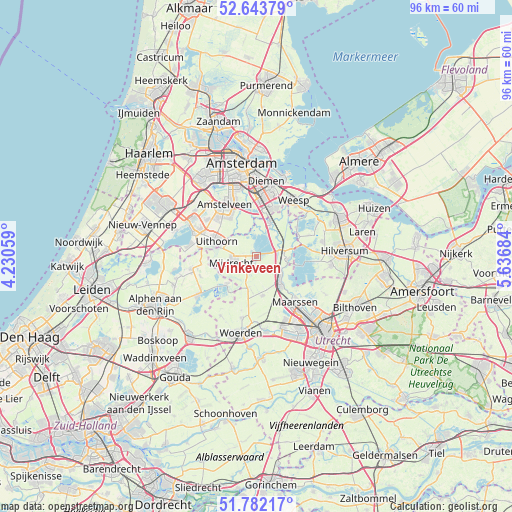
Vinkeveen GPS coordinates[2]
52° 12' 54.252" North, 4° 56' 1.392" East
| Map corner | latitude | longitude |
|---|---|---|
| Upper-left | 52.64379°, | 4.23059° |
| Center: | 52.21507°, | 4.93372° |
| Lower-right: | 51.78217°, | 5.63684° |
| Map W x H: | 95.8×95.8 km | = 59.5×59.5mi |
| max Lat: | 53.48025° ⇑38.3% North |
| Vinkeveen: | 52.21507° |
| min Lat: | ⇓61.7% South 50.76917° |
| min Long | Vinkeveen | max Long |
| 3.38611° | 4.93372° | 7.16528° |
| W 24.6%⇐ | ⇒75.4% E |
Elevation
Elevation of Vinkeveen is 0 m = 0 ft, and this is 15 m = 49 ft below average elevation for this country.
| Max E: |
203 m = 666 ft | 91.3% |
| Avg. | 15 m = 49 ft | |
| Vinkeveen | 0 m = 0 ft | |
Min E: |
-6 m = -20 ft | 8.7% |
See also: Netherlands elevation on elevation.city.
Geographical zone
Vinkeveen is located in North temperate zone (between Tropic of Cancer and the Arctic Circle). Distance of this North polar circle is 1595.4 km =991.3 mi to North.| Distance of | km | miles | from Vinkeveen |
|---|---|---|---|
| North Pole | 4201.3 | 2610.6 | to North |
| Arctic Circle | 1595.4 | 991.3 | to North |
| Tropic Cancer | 3199.9 | 1988.3 | to South |
| Equator | 5805.8 | 3607.6 | to South |


Nearby cities:
15 places around Vinkeveen: (largest is in red/bold)
• Abcoude
6.8 km =4.2 mi,  20°
20°
• Amstelveen
10.7 km =6.6 mi,  333°
333°
• Amsterdam-Zuidoost
10.6 km =6.6 mi,  14°
14°
• Baambrugge
5.1 km =3.2 mi,  47°
47°
• Breukelen
6.5 km =4 mi,  134°
134°
• Horstermeer
10.6 km =6.6 mi,  68°
68°
• Maarssen
11.2 km =7 mi,  138°
138°
• Mijdrecht
4.9 km =3 mi,  259°
259°
• Oud-Loosdrecht
10 km =6.2 mi,  95°
95°
• Ouderkerk aan de Amstel
9.1 km =5.7 mi,  348°
348°
• Spechtenkamp
10.2 km =6.3 mi,  145°
145°
• Uithoorn
7.7 km =4.8 mi,  288°
288°
• Wilnis
3.2 km =2 mi,  230°
230°
• Woerdense Verlaat
8.2 km =5.1 mi,  215°
215°
• Zevenhoven
11.2 km =7 mi,  250°
250°
Sources, notices
• [Note1] Compared only with cities in Netherlands existing in our database
• [Src1] Map data: © OpenStreetMap contributors (CC-BY-SA)
• [Src2] Other city data from geonames.org with taken over terms of usage.
• [Src3] Geographical zone / Annual Mean Temperature by Robert A. Rohde @ Wikipedia
