Zevenhoven geodata
Zevenhoven (South Holland) is a populated place; located in Netherlands in Europe/Amsterdam (GMT+2) time zone. With population of 2,200 people, there are 910 cities with bigger population in this country. Compared to other cities in Netherlands, 58.7% of cities are located further ↓South; 80.6% of cities are located further →East and 100% of cities have higher elevation than Zevenhoven. Note1


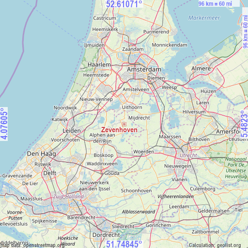
Zevenhoven GPS coordinates[2]
52° 10' 54.012" North, 4° 46' 45.012" East
| Map corner | latitude | longitude |
|---|---|---|
| Upper-left | 52.61071°, | 4.07605° |
| Center: | 52.18167°, | 4.77917° |
| Lower-right: | 51.74845°, | 5.4823° |
| Map W x H: | 95.9×95.9 km | = 59.6×59.6mi |
| max Lat: | 53.48025° ⇑41.3% North |
| Zevenhoven: | 52.18167° |
| min Lat: | ⇓58.7% South 50.76917° |
| min Long | Zevenhoven | max Long |
| 3.38611° | 4.77917° | 7.16528° |
| W 19.4%⇐ | ⇒80.6% E |
Elevation
Elevation of Zevenhoven is -6 m = -20 ft, and this is 21 m = 69 ft below average elevation for this country.
| Max E: |
203 m = 666 ft | 100% |
| Avg. | 15 m = 49 ft | |
| Zevenhoven | -6 m = -20 ft | |
Min E: |
-6 m = -20 ft | 0% |
See also: Netherlands elevation on elevation.city.
Geographical zone
Zevenhoven is located in North temperate zone (between Tropic of Cancer and the Arctic Circle). Distance of this North polar circle is 1599.1 km =993.6 mi to North.| Distance of | km | miles | from Zevenhoven |
|---|---|---|---|
| North Pole | 4205 | 2612.9 | to North |
| Arctic Circle | 1599.1 | 993.6 | to North |
| Tropic Cancer | 3196.1 | 1986 | to South |
| Equator | 5802.1 | 3605.3 | to South |


Nearby cities:
15 places around Zevenhoven: (largest is in red/bold)
• Aalsmeer
8.7 km =5.4 mi,  351°
351°
• Korteraar
3.4 km =2.1 mi,  253°
253°
• Kudelstaart
6.1 km =3.8 mi,  342°
342°
• Langeraar
4.8 km =3 mi,  285°
285°
• Leimuiden
8.8 km =5.5 mi,  302°
302°
• Mijdrecht
6.3 km =3.9 mi,  63°
63°
• Nieuwkoop
3.4 km =2.1 mi,  183°
183°
• Nieuwveen
2.3 km =1.4 mi,  317°
317°
• Oude Wetering
9.9 km =6.2 mi, 291°
• Papenveer
3.7 km =2.3 mi,  275°
275°
• Rijnsaterwoude
7.6 km =4.7 mi, 282°
• Uithoorn
7 km =4.3 mi,  27°
27°
• Wilnis
8.2 km =5.1 mi,  78°
78°
• Woerdense Verlaat
6.5 km =4 mi,  117°
117°
• Woubrugge
9.8 km =6.1 mi,  262°
262°
Sources, notices
• [Note1] Compared only with cities in Netherlands existing in our database
• [Src1] Map data: © OpenStreetMap contributors (CC-BY-SA)
• [Src2] Other city data from geonames.org with taken over terms of usage.
• [Src3] Geographical zone / Annual Mean Temperature by Robert A. Rohde @ Wikipedia
