Aalsmeerderbrug geodata
Aalsmeerderbrug (North Holland) is a populated place; located in Netherlands in Europe/Amsterdam (GMT+2) time zone. With population of 505 people, there are 1833 cities with bigger population in this country. Compared to other cities in Netherlands, 65.6% of cities are located further ↓South; 81.9% of cities are located further →East and 98.2% of cities have higher elevation than Aalsmeerderbrug. Note1


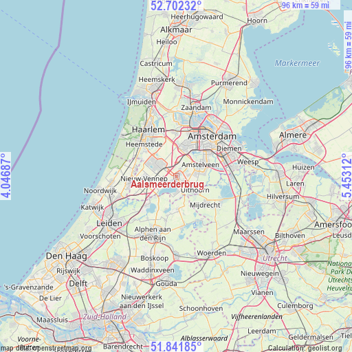
Aalsmeerderbrug GPS coordinates[2]
52° 16' 27.012" North, 4° 45' 0" East
| Map corner | latitude | longitude |
|---|---|---|
| Upper-left | 52.70232°, | 4.04687° |
| Center: | 52.27417°, | 4.75° |
| Lower-right: | 51.84185°, | 5.45312° |
| Map W x H: | 95.7×95.7 km | = 59.5×59.5mi |
| max Lat: | 53.48025° ⇑34.4% North |
| Aalsmeerderbrug: | 52.27417° |
| min Lat: | ⇓65.6% South 50.76917° |
| min Long | Aalsmeerderbrug | max Long |
| 3.38611° | 4.75° | 7.16528° |
| W 18.1%⇐ | ⇒81.9% E |
Elevation
Elevation of Aalsmeerderbrug is -2 m = -7 ft, and this is 17 m = 56 ft below average elevation for this country.
| Max E: |
203 m = 666 ft | 98.2% |
| Avg. | 15 m = 49 ft | |
| Aalsmeerderbrug | -2 m = -7 ft | |
Min E: |
-6 m = -20 ft | 1.8% |
See also: Netherlands elevation on elevation.city.
Geographical zone
Aalsmeerderbrug is located in North temperate zone (between Tropic of Cancer and the Arctic Circle). Distance of this North polar circle is 1588.8 km =987.2 mi to North.| Distance of | km | miles | from Aalsmeerderbrug |
|---|---|---|---|
| North Pole | 4194.7 | 2606.5 | to North |
| Arctic Circle | 1588.8 | 987.2 | to North |
| Tropic Cancer | 3206.4 | 1992.4 | to South |
| Equator | 5812.3 | 3611.6 | to South |


Nearby cities:
15 places around Aalsmeerderbrug: (largest is in red/bold)
• Aalsmeer
1.8 km =1.1 mi,  158°
158°
• Amstelveen
8.3 km =5.2 mi,  69°
69°
• Hoofddorp
5.2 km =3.2 mi,  307°
307°
• Kudelstaart
4.4 km =2.7 mi,  178°
178°
• Langeraar
9.4 km =5.8 mi,  196°
196°
• Leimuiden
7.8 km =4.8 mi,  224°
224°
• Lijnden
8.7 km =5.4 mi,  3°
3°
• Nieuwveen
8.6 km =5.3 mi, 176°
• Oosteinde
3.2 km =2 mi,  79°
79°
• Oude Wetering
9.8 km =6.1 mi,  227°
227°
• Papenveer
10.1 km =6.3 mi,  189°
189°
• Rijnsaterwoude
10.2 km =6.3 mi,  211°
211°
• Uithoorn
6.6 km =4.1 mi,  128°
128°
• Vijfhuizen
9.8 km =6.1 mi,  330°
330°
• Zwaanshoek
10 km =6.2 mi,  295°
295°
Sources, notices
• [Note1] Compared only with cities in Netherlands existing in our database
• [Src1] Map data: © OpenStreetMap contributors (CC-BY-SA)
• [Src2] Other city data from geonames.org with taken over terms of usage.
• [Src3] Geographical zone / Annual Mean Temperature by Robert A. Rohde @ Wikipedia
