Mijdrecht geodata
Mijdrecht (Utrecht) is a populated place; located in Netherlands in Europe/Amsterdam (GMT+2) time zone. With population of 15,230 people, there are 222 cities with bigger population in this country. Compared to other cities in Netherlands, 60.9% of cities are located further ↓South; 77.5% of cities are located further →East and 99.2% of cities have higher elevation than Mijdrecht. Note1


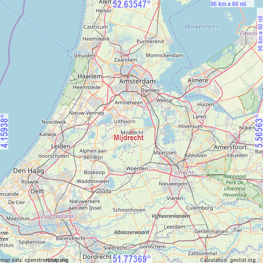
Mijdrecht GPS coordinates[2]
52° 12' 24.012" North, 4° 51' 45" East
| Map corner | latitude | longitude |
|---|---|---|
| Upper-left | 52.63547°, | 4.15938° |
| Center: | 52.20667°, | 4.8625° |
| Lower-right: | 51.77369°, | 5.56563° |
| Map W x H: | 95.8×95.8 km | = 59.5×59.5mi |
| max Lat: | 53.48025° ⇑39.1% North |
| Mijdrecht: | 52.20667° |
| min Lat: | ⇓60.9% South 50.76917° |
| min Long | Mijdrecht | max Long |
| 3.38611° | 4.8625° | 7.16528° |
| W 22.5%⇐ | ⇒77.5% E |
Elevation
Elevation of Mijdrecht is -3 m = -10 ft, and this is 18 m = 59 ft below average elevation for this country.
| Max E: |
203 m = 666 ft | 99.2% |
| Avg. | 15 m = 49 ft | |
| Mijdrecht | -3 m = -10 ft | |
Min E: |
-6 m = -20 ft | 0.8% |
See also: Netherlands elevation on elevation.city.
Geographical zone
Mijdrecht is located in North temperate zone (between Tropic of Cancer and the Arctic Circle). Distance of this North polar circle is 1596.3 km =991.9 mi to North.| Distance of | km | miles | from Mijdrecht |
|---|---|---|---|
| North Pole | 4202.2 | 2611.1 | to North |
| Arctic Circle | 1596.3 | 991.9 | to North |
| Tropic Cancer | 3198.9 | 1987.7 | to South |
| Equator | 5804.8 | 3606.9 | to South |


Nearby cities:
15 places around Mijdrecht: (largest is in red/bold)
• Aalsmeer
9.1 km =5.7 mi,  309°
309°
• Baambrugge
9.6 km =6 mi,  63°
63°
• Breukelen
10.1 km =6.3 mi,  110°
110°
• Korteraar
9.6 km =6 mi,  247°
247°
• Kudelstaart
8.2 km =5.1 mi,  291°
291°
• Nieuwkoop
8.5 km =5.3 mi,  223°
223°
• Nieuwveen
7.3 km =4.5 mi,  261°
261°
• Oosteinde
9.3 km =5.8 mi,  330°
330°
• Ouderkerk aan de Amstel
10.3 km =6.4 mi,  17°
17°
• Papenveer
9.7 km =6 mi, 255°
• Uithoorn
4.2 km =2.6 mi,  324°
324°
• Vinkeveen
4.9 km =3 mi,  79°
79°
• Wilnis
2.6 km =1.6 mi,  115°
115°
• Woerdense Verlaat
5.7 km =3.5 mi,  179°
179°
• Zevenhoven
6.3 km =3.9 mi,  243°
243°
Sources, notices
• [Note1] Compared only with cities in Netherlands existing in our database
• [Src1] Map data: © OpenStreetMap contributors (CC-BY-SA)
• [Src2] Other city data from geonames.org with taken over terms of usage.
• [Src3] Geographical zone / Annual Mean Temperature by Robert A. Rohde @ Wikipedia
