Tuindorp geodata
Tuindorp (South Holland) is a section of populated place; located in Netherlands in Europe/Amsterdam (GMT+2) time zone. With population of 1,040 people, there are 1370 cities with bigger population in this country. Compared to other cities in Netherlands, 55.5% of cities are located further ↑North; 92.4% of cities are located further →East and 91.3% of cities have higher elevation than Tuindorp. Note1


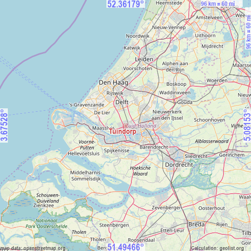
Tuindorp GPS coordinates[2]
51° 55' 49.152" North, 4° 22' 42.24" East
| Map corner | latitude | longitude |
|---|---|---|
| Upper-left | 52.36179°, | 3.67528° |
| Center: | 51.93032°, | 4.3784° |
| Lower-right: | 51.49466°, | 5.08153° |
| Map W x H: | 96.4×96.4 km | = 59.9×59.9mi |
| max Lat: | 53.48025° ⇑55.5% North |
| Tuindorp: | 51.93032° |
| min Lat: | ⇓44.5% South 50.76917° |
| min Long | Tuindorp | max Long |
| 3.38611° | 4.3784° | 7.16528° |
| W 7.6%⇐ | ⇒92.4% E |
Elevation
Elevation of Tuindorp is 0 m = 0 ft, and this is 15 m = 49 ft below average elevation for this country.
| Max E: |
203 m = 666 ft | 91.3% |
| Avg. | 15 m = 49 ft | |
| Tuindorp | 0 m = 0 ft | |
Min E: |
-6 m = -20 ft | 8.7% |
See also: Netherlands elevation on elevation.city.
Geographical zone
Tuindorp is located in North temperate zone (between Tropic of Cancer and the Arctic Circle). Distance of this North polar circle is 1627.1 km =1011 mi to North.| Distance of | km | miles | from Tuindorp |
|---|---|---|---|
| North Pole | 4233 | 2630.3 | to North |
| Arctic Circle | 1627.1 | 1011 | to North |
| Tropic Cancer | 3168.2 | 1968.6 | to South |
| Equator | 5774.1 | 3587.9 | to South |


Nearby cities:
15 places around Tuindorp: (largest is in red/bold)
• Carnisse
8.2 km =5.1 mi,  123°
123°
• Delfshaven
5.9 km =3.7 mi, 118°
• Heijplaat
5 km =3.1 mi,  144°
144°
• Katendrecht
7.9 km =4.9 mi,  114°
114°
• Kop van Zuid
7.9 km =4.9 mi, 110°
• Maasland
7.3 km =4.5 mi,  273°
273°
• Overschie
3.5 km =2.2 mi,  74°
74°
• Pernis
4.7 km =2.9 mi,  171°
171°
• Rhoon
8.6 km =5.3 mi,  159°
159°
• Rotterdam
7 km =4.3 mi,  97°
97°
• Schiebroek
7.1 km =4.4 mi,  63°
63°
• Schiedam
1.4 km =0.9 mi,  149°
149°
• Schipluiden
6.7 km =4.2 mi,  318°
318°
• Spangen
4.2 km =2.6 mi, 110°
• Vlaardingen
3.2 km =2 mi,  231°
231°
Sources, notices
• [Note1] Compared only with cities in Netherlands existing in our database
• [Src1] Map data: © OpenStreetMap contributors (CC-BY-SA)
• [Src2] Other city data from geonames.org with taken over terms of usage.
• [Src3] Geographical zone / Annual Mean Temperature by Robert A. Rohde @ Wikipedia
