Vlaardingen geodata
Vlaardingen (South Holland) is a populated place; located in Netherlands in Europe/Amsterdam (GMT+2) time zone. With population of 73,798 people, there are 39 cities with bigger population in this country. Compared to other cities in Netherlands, 56.8% of cities are located further ↑North; 93% of cities are located further →East and 74.9% of cities have higher elevation than Vlaardingen. Note1


Vlaardingen GPS coordinates[2]
51° 54' 45" North, 4° 20' 30.012" East
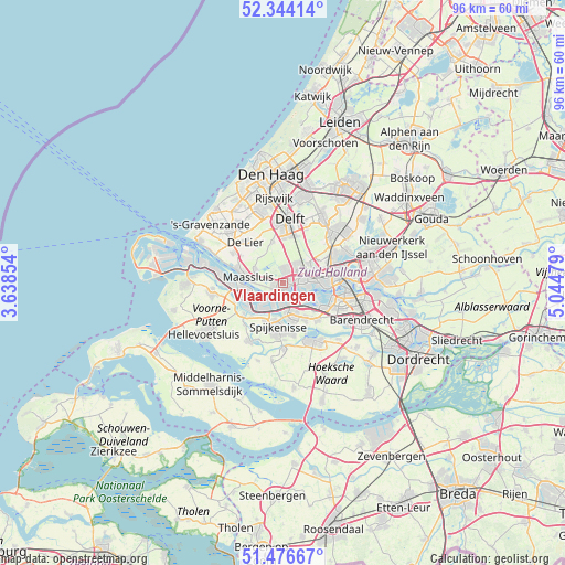
| Map corner | latitude | longitude |
|---|---|---|
| Upper-left | 52.34414°, | 3.63854° |
| Center: | 51.9125°, | 4.34167° |
| Lower-right: | 51.47667°, | 5.04479° |
| Map W x H: | 96.5×96.5 km | = 60×60mi |
| max Lat: | 53.48025° ⇑56.8% North |
| Vlaardingen: | 51.9125° |
| min Lat: | ⇓43.2% South 50.76917° |
| min Long | Vlaardingen | max Long |
| 3.38611° | 4.34167° | 7.16528° |
| W 7%⇐ | ⇒93% E |
Elevation
Elevation of Vlaardingen is 2 m = 7 ft, and this is 13 m = 43 ft below average elevation for this country.
| Max E: |
203 m = 666 ft | 74.9% |
| Avg. | 15 m = 49 ft | |
| Vlaardingen | 2 m = 7 ft | |
Min E: |
-6 m = -20 ft | 25.1% |
See also: Vlaardingen elevation on elevation.city.
Geographical zone
Vlaardingen is located in North temperate zone (between Tropic of Cancer and the Arctic Circle). Distance of this North polar circle is 1629 km =1012.2 mi to North.| Distance of | km | miles | from Vlaardingen |
|---|---|---|---|
| North Pole | 4234.9 | 2631.4 | to North |
| Arctic Circle | 1629 | 1012.2 | to North |
| Tropic Cancer | 3166.2 | 1967.4 | to South |
| Equator | 5772.1 | 3586.6 | to South |


Nearby cities:
15 places around Vlaardingen: (largest is in red/bold)
• De Lier
9.4 km =5.8 mi,  317°
317°
• Delfshaven
7.7 km =4.8 mi,  96°
96°
• Heijplaat
5.8 km =3.6 mi,  111°
111°
• Maasland
5.3 km =3.3 mi,  296°
296°
• Maassluis
6.4 km =4 mi,  280°
280°
• Overschie
6.6 km =4.1 mi,  63°
63°
• Pernis
4.2 km =2.6 mi,  129°
129°
• Rhoon
8.2 km =5.1 mi,  137°
137°
• Rozenburg
6.5 km =4 mi,  261°
261°
• Schiedam
3.3 km =2.1 mi,  77°
77°
• Schipluiden
7.3 km =4.5 mi,  344°
344°
• Spangen
6.4 km =4 mi,  85°
85°
• Spijkenisse
7.6 km =4.7 mi,  186°
186°
• Tuindorp
3.2 km =2 mi,  51°
51°
• Zwartewaal
8.9 km =5.5 mi,  248°
248°
Sources, notices
• [Note1] Compared only with cities in Netherlands existing in our database
• [Src1] Map data: © OpenStreetMap contributors (CC-BY-SA)
• [Src2] Other city data from geonames.org with taken over terms of usage.
• [Src3] Geographical zone / Annual Mean Temperature by Robert A. Rohde @ Wikipedia
