Schipluiden geodata
Schipluiden (South Holland) is a populated place; located in Netherlands in Europe/Amsterdam (GMT+2) time zone. With population of 3,635 people, there are 648 cities with bigger population in this country. Compared to other cities in Netherlands, 52.7% of cities are located further ↑North; 93.6% of cities are located further →East and 96.1% of cities have higher elevation than Schipluiden. Note1


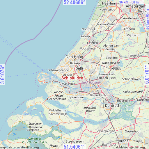
Schipluiden GPS coordinates[2]
51° 58' 32.988" North, 4° 18' 50.004" East
| Map corner | latitude | longitude |
|---|---|---|
| Upper-left | 52.40686°, | 3.61076° |
| Center: | 51.97583°, | 4.31389° |
| Lower-right: | 51.54061°, | 5.01701° |
| Map W x H: | 96.3×96.3 km | = 59.8×59.8mi |
| max Lat: | 53.48025° ⇑52.7% North |
| Schipluiden: | 51.97583° |
| min Lat: | ⇓47.3% South 50.76917° |
| min Long | Schipluiden | max Long |
| 3.38611° | 4.31389° | 7.16528° |
| W 6.4%⇐ | ⇒93.6% E |
Elevation
Elevation of Schipluiden is -1 m = -3 ft, and this is 16 m = 52 ft below average elevation for this country.
| Max E: |
203 m = 666 ft | 96.1% |
| Avg. | 15 m = 49 ft | |
| Schipluiden | -1 m = -3 ft | |
Min E: |
-6 m = -20 ft | 3.9% |
See also: Netherlands elevation on elevation.city.
Geographical zone
Schipluiden is located in North temperate zone (between Tropic of Cancer and the Arctic Circle). Distance of this North polar circle is 1622 km =1007.9 mi to North.| Distance of | km | miles | from Schipluiden |
|---|---|---|---|
| North Pole | 4227.9 | 2627.1 | to North |
| Arctic Circle | 1622 | 1007.9 | to North |
| Tropic Cancer | 3173.3 | 1971.8 | to South |
| Equator | 5779.2 | 3591 | to South |


Nearby cities:
15 places around Schipluiden: (largest is in red/bold)
• De Lier
4.5 km =2.8 mi,  268°
268°
• Delft
4.5 km =2.8 mi,  39°
39°
• Honselersdijk
7 km =4.3 mi,  299°
299°
• Kwintsheul
5.8 km =3.6 mi,  316°
316°
• Maasdijk
7.1 km =4.4 mi,  254°
254°
• Maasland
5.4 km =3.4 mi,  211°
211°
• Maassluis
7.3 km =4.5 mi,  216°
216°
• Naaldwijk
7.4 km =4.6 mi,  285°
285°
• Plaspoelpolder
7.1 km =4.4 mi,  9°
9°
• Rijswijk
6.8 km =4.2 mi, 6°
• Schiedam
8.1 km =5 mi,  140°
140°
• Sion
4.3 km =2.7 mi, 10°
• Strijp
6.2 km =3.9 mi,  352°
352°
• Tuindorp
6.7 km =4.2 mi, 138°
• Vlaardingen
7.3 km =4.5 mi,  164°
164°
Sources, notices
• [Note1] Compared only with cities in Netherlands existing in our database
• [Src1] Map data: © OpenStreetMap contributors (CC-BY-SA)
• [Src2] Other city data from geonames.org with taken over terms of usage.
• [Src3] Geographical zone / Annual Mean Temperature by Robert A. Rohde @ Wikipedia
