Surhuizum geodata
Surhuizum (Friesland) is a populated place; located in Netherlands in Europe/Amsterdam (GMT+2) time zone. With population of 925 people, there are 1447 cities with bigger population in this country. Compared to other cities in Netherlands, 93.4% of cities are located further ↓South; 82.7% of cities are located further ←West and 83.9% of cities have higher elevation than Surhuizum. Note1


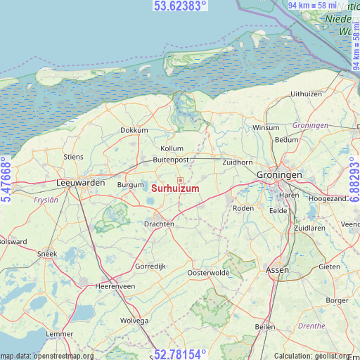
Surhuizum GPS coordinates[2]
53° 12' 17.1" North, 6° 10' 47.316" East
| Map corner | latitude | longitude |
|---|---|---|
| Upper-left | 53.62383°, | 5.47668° |
| Center: | 53.20475°, | 6.17981° |
| Lower-right: | 52.78154°, | 6.88293° |
| Map W x H: | 93.7×93.7 km | = 58.2×58.2mi |
| max Lat: | 53.48025° ⇑6.6% North |
| Surhuizum: | 53.20475° |
| min Lat: | ⇓93.4% South 50.76917° |
| min Long | Surhuizum | max Long |
| 3.38611° | 6.17981° | 7.16528° |
| W 82.7%⇐ | ⇒17.3% E |
Elevation
Elevation of Surhuizum is 1 m = 3 ft, and this is 14 m = 46 ft below average elevation for this country.
| Max E: |
203 m = 666 ft | 83.9% |
| Avg. | 15 m = 49 ft | |
| Surhuizum | 1 m = 3 ft | |
Min E: |
-6 m = -20 ft | 16.1% |
See also: Netherlands elevation on elevation.city.
Geographical zone
Surhuizum is located in North temperate zone (between Tropic of Cancer and the Arctic Circle). Distance of this North polar circle is 1485.4 km =923 mi to North.| Distance of | km | miles | from Surhuizum |
|---|---|---|---|
| North Pole | 4091.2 | 2542.2 | to North |
| Arctic Circle | 1485.4 | 923 | to North |
| Tropic Cancer | 3309.9 | 2056.7 | to South |
| Equator | 5915.8 | 3675.9 | to South |


Nearby cities:
15 places around Surhuizum: (largest is in red/bold)
• Augustinusga
1.9 km =1.2 mi,  320°
320°
• Boelenslaan
5.3 km =3.3 mi,  205°
205°
• Buitenpost
5.7 km =3.5 mi,  335°
335°
• Doezum
4.6 km =2.9 mi,  95°
95°
• Drogeham
4.5 km =2.8 mi,  266°
266°
• Gerkesklooster
4 km =2.5 mi,  23°
23°
• Grootegast
6.3 km =3.9 mi,  82°
82°
• Harkema
3.9 km =2.4 mi,  232°
232°
• Houtigehage
6.3 km =3.9 mi,  201°
201°
• Jistrum
7.6 km =4.7 mi,  275°
275°
• Kootstertille
5.9 km =3.7 mi, 278°
• Kornhorn
4.9 km =3 mi,  121°
121°
• Lutjegast
6.2 km =3.9 mi,  57°
57°
• Surhuisterveen
2.3 km =1.4 mi, 195°
• Twijzel
6.7 km =4.2 mi,  296°
296°
Sources, notices
• [Note1] Compared only with cities in Netherlands existing in our database
• [Src1] Map data: © OpenStreetMap contributors (CC-BY-SA)
• [Src2] Other city data from geonames.org with taken over terms of usage.
• [Src3] Geographical zone / Annual Mean Temperature by Robert A. Rohde @ Wikipedia
