Gerkesklooster geodata
Gerkesklooster (Friesland) is a populated place; located in Netherlands in Europe/Amsterdam (GMT+2) time zone. With population of 730 people, there are 1585 cities with bigger population in this country. Compared to other cities in Netherlands, 95.2% of cities are located further ↓South; 83.3% of cities are located further ←West and 91.3% of cities have higher elevation than Gerkesklooster. Note1


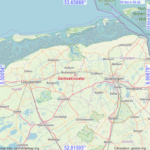
Gerkesklooster GPS coordinates[2]
53° 14' 16.584" North, 6° 12' 13.212" East
| Map corner | latitude | longitude |
|---|---|---|
| Upper-left | 53.65669°, | 5.50054° |
| Center: | 53.23794°, | 6.20367° |
| Lower-right: | 52.81505°, | 6.90679° |
| Map W x H: | 93.6×93.6 km | = 58.2×58.2mi |
| max Lat: | 53.48025° ⇑4.8% North |
| Gerkesklooster: | 53.23794° |
| min Lat: | ⇓95.2% South 50.76917° |
| min Long | Gerkesklooster | max Long |
| 3.38611° | 6.20367° | 7.16528° |
| W 83.3%⇐ | ⇒16.7% E |
Elevation
Elevation of Gerkesklooster is 0 m = 0 ft, and this is 15 m = 49 ft below average elevation for this country.
| Max E: |
203 m = 666 ft | 91.3% |
| Avg. | 15 m = 49 ft | |
| Gerkesklooster | 0 m = 0 ft | |
Min E: |
-6 m = -20 ft | 8.7% |
See also: Netherlands elevation on elevation.city.
Geographical zone
Gerkesklooster is located in North temperate zone (between Tropic of Cancer and the Arctic Circle). Distance of this North polar circle is 1481.7 km =920.7 mi to North.| Distance of | km | miles | from Gerkesklooster |
|---|---|---|---|
| North Pole | 4087.6 | 2539.9 | to North |
| Arctic Circle | 1481.7 | 920.7 | to North |
| Tropic Cancer | 3313.6 | 2059 | to South |
| Equator | 5919.5 | 3678.2 | to South |


Nearby cities:
15 places around Gerkesklooster: (largest is in red/bold)
• Augustinusga
3.6 km =2.2 mi,  231°
231°
• Buitenpost
4.2 km =2.6 mi,  291°
291°
• Burum
4.3 km =2.7 mi,  23°
23°
• Doezum
5.1 km =3.2 mi,  144°
144°
• Drogeham
7.3 km =4.5 mi,  236°
236°
• Grijpskerk
7.5 km =4.7 mi,  68°
68°
• Grootegast
5.4 km =3.4 mi,  121°
121°
• Harkema
7.7 km =4.8 mi,  217°
217°
• Kollum
5.5 km =3.4 mi,  322°
322°
• Kornhorn
6.8 km =4.2 mi,  157°
157°
• Lutjegast
3.7 km =2.3 mi,  96°
96°
• Oudwoude
7.7 km =4.8 mi,  309°
309°
• Surhuisterveen
6.3 km =3.9 mi,  200°
200°
• Surhuizum
4 km =2.5 mi, 203°
• Twijzel
7.6 km =4.7 mi,  264°
264°
Sources, notices
• [Note1] Compared only with cities in Netherlands existing in our database
• [Src1] Map data: © OpenStreetMap contributors (CC-BY-SA)
• [Src2] Other city data from geonames.org with taken over terms of usage.
• [Src3] Geographical zone / Annual Mean Temperature by Robert A. Rohde @ Wikipedia
