Grootegast geodata
Grootegast (Groningen) is a populated place; located in Netherlands in Europe/Amsterdam (GMT+2) time zone. With population of 3,350 people, there are 705 cities with bigger population in this country. Compared to other cities in Netherlands, 93.8% of cities are located further ↓South; 85% of cities are located further ←West and 74.9% of cities have higher elevation than Grootegast. Note1


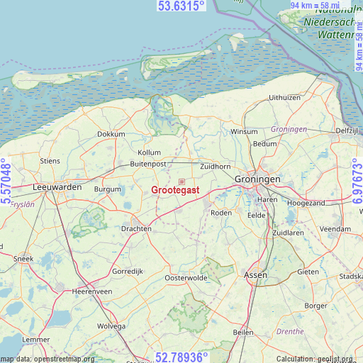
Grootegast GPS coordinates[2]
53° 12' 45" North, 6° 16' 24.996" East
| Map corner | latitude | longitude |
|---|---|---|
| Upper-left | 53.6315°, | 5.57048° |
| Center: | 53.2125°, | 6.27361° |
| Lower-right: | 52.78936°, | 6.97673° |
| Map W x H: | 93.6×93.6 km | = 58.2×58.2mi |
| max Lat: | 53.48025° ⇑6.2% North |
| Grootegast: | 53.2125° |
| min Lat: | ⇓93.8% South 50.76917° |
| min Long | Grootegast | max Long |
| 3.38611° | 6.27361° | 7.16528° |
| W 85%⇐ | ⇒15% E |
Elevation
Elevation of Grootegast is 2 m = 7 ft, and this is 13 m = 43 ft below average elevation for this country.
| Max E: |
203 m = 666 ft | 74.9% |
| Avg. | 15 m = 49 ft | |
| Grootegast | 2 m = 7 ft | |
Min E: |
-6 m = -20 ft | 25.1% |
See also: Netherlands elevation on elevation.city.
Geographical zone
Grootegast is located in North temperate zone (between Tropic of Cancer and the Arctic Circle). Distance of this North polar circle is 1484.5 km =922.4 mi to North.| Distance of | km | miles | from Grootegast |
|---|---|---|---|
| North Pole | 4090.4 | 2541.7 | to North |
| Arctic Circle | 1484.5 | 922.4 | to North |
| Tropic Cancer | 3310.8 | 2057.2 | to South |
| Equator | 5916.7 | 3676.5 | to South |


Nearby cities:
15 places around Grootegast: (largest is in red/bold)
• Augustinusga
7.5 km =4.7 mi,  274°
274°
• Burum
7.4 km =4.6 mi,  336°
336°
• Doezum
2.1 km =1.3 mi,  232°
232°
• Gerkesklooster
5.4 km =3.4 mi,  301°
301°
• Grijpskerk
6 km =3.7 mi,  22°
22°
• Kornhorn
4 km =2.5 mi,  210°
210°
• Leek
8.8 km =5.5 mi,  129°
129°
• Lutjegast
2.6 km =1.6 mi, 337°
• Marum
7.6 km =4.7 mi,  185°
185°
• Niebert
6.8 km =4.2 mi,  147°
147°
• Niekerk
5.5 km =3.4 mi,  75°
75°
• Nuis
7.2 km =4.5 mi,  162°
162°
• Oldekerk
4.5 km =2.8 mi, 80°
• Surhuisterveen
7.5 km =4.7 mi,  245°
245°
• Surhuizum
6.3 km =3.9 mi,  262°
262°
Sources, notices
• [Note1] Compared only with cities in Netherlands existing in our database
• [Src1] Map data: © OpenStreetMap contributors (CC-BY-SA)
• [Src2] Other city data from geonames.org with taken over terms of usage.
• [Src3] Geographical zone / Annual Mean Temperature by Robert A. Rohde @ Wikipedia
