Buitenpost geodata
Buitenpost (Friesland) is a populated place; located in Netherlands in Europe/Amsterdam (GMT+2) time zone. With population of 5,120 people, there are 473 cities with bigger population in this country. Compared to other cities in Netherlands, 95.9% of cities are located further ↓South; 81.5% of cities are located further ←West and 65.8% of cities have higher elevation than Buitenpost. Note1


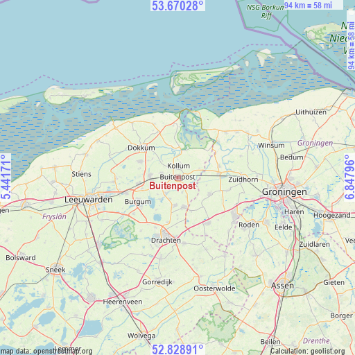
Buitenpost GPS coordinates[2]
53° 15' 5.976" North, 6° 8' 41.388" East
| Map corner | latitude | longitude |
|---|---|---|
| Upper-left | 53.67028°, | 5.44171° |
| Center: | 53.25166°, | 6.14483° |
| Lower-right: | 52.82891°, | 6.84796° |
| Map W x H: | 93.6×93.5 km | = 58.2×58.1mi |
| max Lat: | 53.48025° ⇑4.1% North |
| Buitenpost: | 53.25166° |
| min Lat: | ⇓95.9% South 50.76917° |
| min Long | Buitenpost | max Long |
| 3.38611° | 6.14483° | 7.16528° |
| W 81.5%⇐ | ⇒18.5% E |
Elevation
Elevation of Buitenpost is 3 m = 10 ft, and this is 12 m = 39 ft below average elevation for this country.
| Max E: |
203 m = 666 ft | 65.8% |
| Avg. | 15 m = 49 ft | |
| Buitenpost | 3 m = 10 ft | |
Min E: |
-6 m = -20 ft | 34.2% |
See also: Netherlands elevation on elevation.city.
Geographical zone
Buitenpost is located in North temperate zone (between Tropic of Cancer and the Arctic Circle). Distance of this North polar circle is 1480.1 km =919.7 mi to North.| Distance of | km | miles | from Buitenpost |
|---|---|---|---|
| North Pole | 4086 | 2538.9 | to North |
| Arctic Circle | 1480.1 | 919.7 | to North |
| Tropic Cancer | 3315.1 | 2059.9 | to South |
| Equator | 5921 | 3679.1 | to South |


Nearby cities:
15 places around Buitenpost: (largest is in red/bold)
• Augustinusga
3.9 km =2.4 mi,  163°
163°
• Burum
6.1 km =3.8 mi,  66°
66°
• De Westereen
7.2 km =4.5 mi,  274°
274°
• Drogeham
5.9 km =3.7 mi,  201°
201°
• Gerkesklooster
4.2 km =2.6 mi,  111°
111°
• Jistrum
6.8 km =4.2 mi,  229°
229°
• Kollum
2.9 km =1.8 mi,  10°
10°
• Kollumerzwaag
4.8 km =3 mi,  284°
284°
• Kootstertille
5.6 km =3.5 mi,  218°
218°
• Oudwoude
3.9 km =2.4 mi,  329°
329°
• Surhuisterveen
7.6 km =4.7 mi,  167°
167°
• Surhuizum
5.7 km =3.5 mi, 155°
• Twijzel
4.3 km =2.7 mi,  238°
238°
• Twijzelerheide
6.7 km =4.2 mi,  258°
258°
• Zwagerbosch
6.5 km =4 mi, 266°
Sources, notices
• [Note1] Compared only with cities in Netherlands existing in our database
• [Src1] Map data: © OpenStreetMap contributors (CC-BY-SA)
• [Src2] Other city data from geonames.org with taken over terms of usage.
• [Src3] Geographical zone / Annual Mean Temperature by Robert A. Rohde @ Wikipedia
