Steensel geodata
Steensel (North Brabant) is a populated place; located in Netherlands in Europe/Amsterdam (GMT+2) time zone. With population of 1,280 people, there are 1248 cities with bigger population in this country. Compared to other cities in Netherlands, 87.1% of cities are located further ↑North; 62.3% of cities are located further →East and 86.2% of cities have lower elevation than Steensel. Note1


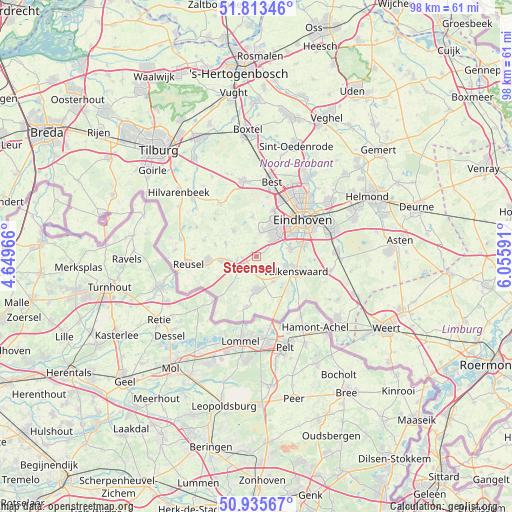
Steensel GPS coordinates[2]
51° 22' 36.012" North, 5° 21' 10.008" East
| Map corner | latitude | longitude |
|---|---|---|
| Upper-left | 51.81346°, | 4.64966° |
| Center: | 51.37667°, | 5.35278° |
| Lower-right: | 50.93567°, | 6.05591° |
| Map W x H: | 97.6×97.6 km | = 60.6×60.6mi |
| max Lat: | 53.48025° ⇑87.1% North |
| Steensel: | 51.37667° |
| min Lat: | ⇓12.9% South 50.76917° |
| min Long | Steensel | max Long |
| 3.38611° | 5.35278° | 7.16528° |
| W 37.7%⇐ | ⇒62.3% E |
Elevation
Elevation of Steensel is 28 m = 92 ft, and this is 13 m = 43 ft above average elevation for this country.
| Max E: |
203 m = 666 ft | 13.8% |
| Steensel | 28 m 92 ft | |
| Avg. | 15 m = 49 ft | |
Min E: |
-6 m = -20 ft | 86.2% |
See also: Netherlands elevation on elevation.city.
Geographical zone
Steensel is located in North temperate zone (between Tropic of Cancer and the Arctic Circle). Distance of this North polar circle is 1688.6 km =1049.2 mi to North.| Distance of | km | miles | from Steensel |
|---|---|---|---|
| North Pole | 4294.5 | 2668.5 | to North |
| Arctic Circle | 1688.6 | 1049.2 | to North |
| Tropic Cancer | 3106.6 | 1930.4 | to South |
| Equator | 5712.6 | 3549.6 | to South |


Nearby cities:
15 places around Steensel: (largest is in red/bold)
• Bergeijk
6.4 km =4 mi,  176°
176°
• Dommelen
6.6 km =4.1 mi,  120°
120°
• Duizel
4 km =2.5 mi,  256°
256°
• Eersel
3.2 km =2 mi,  228°
228°
• Hapert
6.7 km =4.2 mi, 262°
• Hoogeloon
6.3 km =3.9 mi,  291°
291°
• Meerveldhoven
6.3 km =3.9 mi,  44°
44°
• Oerle
5.3 km =3.3 mi,  14°
14°
• Ooievaarsnest
7.1 km =4.4 mi,  51°
51°
• Riethoven
3.5 km =2.2 mi,  136°
136°
• Veldhoven
5.8 km =3.6 mi, 36°
• Waalre
6.5 km =4 mi,  80°
80°
• Westerhoven
5.7 km =3.5 mi,  148°
148°
• Zeelst
6.9 km =4.3 mi, 39°
• Zonderwijk
4.8 km =3 mi, 36°
Sources, notices
• [Note1] Compared only with cities in Netherlands existing in our database
• [Src1] Map data: © OpenStreetMap contributors (CC-BY-SA)
• [Src2] Other city data from geonames.org with taken over terms of usage.
• [Src3] Geographical zone / Annual Mean Temperature by Robert A. Rohde @ Wikipedia
