Westerhoven geodata
Westerhoven (North Brabant) is a populated place; located in Netherlands in Europe/Amsterdam (GMT+2) time zone. With population of 1,635 people, there are 1064 cities with bigger population in this country. Compared to other cities in Netherlands, 88.5% of cities are located further ↑North; 60.8% of cities are located further →East and 85.2% of cities have lower elevation than Westerhoven. Note1


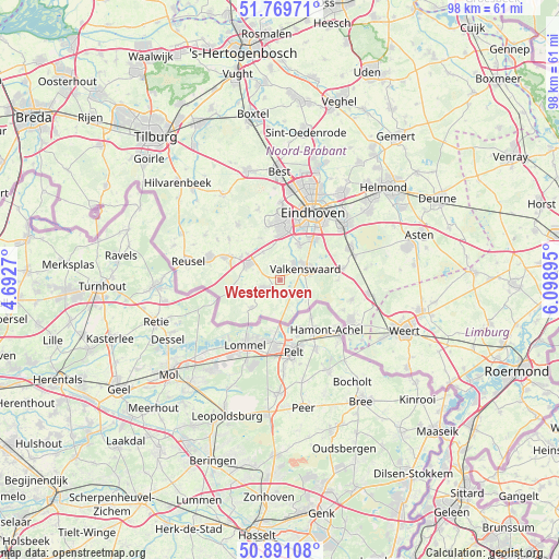
Westerhoven GPS coordinates[2]
51° 19' 57" North, 5° 23' 44.988" East
| Map corner | latitude | longitude |
|---|---|---|
| Upper-left | 51.76971°, | 4.6927° |
| Center: | 51.3325°, | 5.39583° |
| Lower-right: | 50.89108°, | 6.09895° |
| Map W x H: | 97.7×97.7 km | = 60.7×60.7mi |
| max Lat: | 53.48025° ⇑88.5% North |
| Westerhoven: | 51.3325° |
| min Lat: | ⇓11.5% South 50.76917° |
| min Long | Westerhoven | max Long |
| 3.38611° | 5.39583° | 7.16528° |
| W 39.2%⇐ | ⇒60.8% E |
Elevation
Elevation of Westerhoven is 27 m = 89 ft, and this is 12 m = 39 ft above average elevation for this country.
| Max E: |
203 m = 666 ft | 14.8% |
| Westerhoven | 27 m 89 ft | |
| Avg. | 15 m = 49 ft | |
Min E: |
-6 m = -20 ft | 85.2% |
See also: Netherlands elevation on elevation.city.
Geographical zone
Westerhoven is located in North temperate zone (between Tropic of Cancer and the Arctic Circle). Distance of this North polar circle is 1693.5 km =1052.3 mi to North.| Distance of | km | miles | from Westerhoven |
|---|---|---|---|
| North Pole | 4299.4 | 2671.5 | to North |
| Arctic Circle | 1693.5 | 1052.3 | to North |
| Tropic Cancer | 3101.7 | 1927.3 | to South |
| Equator | 5707.6 | 3546.5 | to South |


Nearby cities:
15 places around Westerhoven: (largest is in red/bold)
• Aalst
9.1 km =5.7 mi,  38°
38°
• Bergeijk
3 km =1.9 mi,  240°
240°
• Borkel
5 km =3.1 mi,  141°
141°
• Dommelen
3.1 km =1.9 mi,  60°
60°
• Duizel
7.9 km =4.9 mi,  300°
300°
• Eersel
6.1 km =3.8 mi, 297°
• Geenhoven
5.4 km =3.4 mi, 56°
• Luyksgestel
7 km =4.3 mi,  226°
226°
• Riethoven
2.5 km =1.6 mi,  346°
346°
• Steensel
5.7 km =3.5 mi,  328°
328°
• Valkenswaard
4.9 km =3 mi,  65°
65°
• Voldijn
9.2 km =5.7 mi,  34°
34°
• Waalre
6.9 km =4.3 mi, 29°
• Weebosch
7.5 km =4.7 mi,  249°
249°
• Zonderwijk
8.8 km =5.5 mi,  358°
358°
Sources, notices
• [Note1] Compared only with cities in Netherlands existing in our database
• [Src1] Map data: © OpenStreetMap contributors (CC-BY-SA)
• [Src2] Other city data from geonames.org with taken over terms of usage.
• [Src3] Geographical zone / Annual Mean Temperature by Robert A. Rohde @ Wikipedia
