Eersel geodata
Eersel (North Brabant) is a populated place; located in Netherlands in Europe/Amsterdam (GMT+2) time zone. With population of 18,185 people, there are 194 cities with bigger population in this country. Compared to other cities in Netherlands, 87.9% of cities are located further ↑North; 62.8% of cities are located further →East and 87.8% of cities have lower elevation than Eersel. Note1


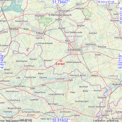
Eersel GPS coordinates[2]
51° 21' 27" North, 5° 19' 5.016" East
| Map corner | latitude | longitude |
|---|---|---|
| Upper-left | 51.79447°, | 4.61494° |
| Center: | 51.3575°, | 5.31806° |
| Lower-right: | 50.91632°, | 6.02119° |
| Map W x H: | 97.6×97.6 km | = 60.6×60.6mi |
| max Lat: | 53.48025° ⇑87.9% North |
| Eersel: | 51.3575° |
| min Lat: | ⇓12.1% South 50.76917° |
| min Long | Eersel | max Long |
| 3.38611° | 5.31806° | 7.16528° |
| W 37.2%⇐ | ⇒62.8% E |
Elevation
Elevation of Eersel is 30 m = 98 ft, and this is 15 m = 49 ft above average elevation for this country.
| Max E: |
203 m = 666 ft | 12.2% |
| Eersel | 30 m 98 ft | |
| Avg. | 15 m = 49 ft | |
Min E: |
-6 m = -20 ft | 87.8% |
See also: Netherlands elevation on elevation.city.
Geographical zone
Eersel is located in North temperate zone (between Tropic of Cancer and the Arctic Circle). Distance of this North polar circle is 1690.8 km =1050.6 mi to North.| Distance of | km | miles | from Eersel |
|---|---|---|---|
| North Pole | 4296.6 | 2669.8 | to North |
| Arctic Circle | 1690.8 | 1050.6 | to North |
| Tropic Cancer | 3104.5 | 1929 | to South |
| Equator | 5710.4 | 3548.3 | to South |


Nearby cities:
15 places around Eersel: (largest is in red/bold)
• Bergeijk
5.1 km =3.2 mi,  146°
146°
• Bladel
6.9 km =4.3 mi,  280°
280°
• Casteren
7.1 km =4.4 mi,  307°
307°
• Dommelen
8.1 km =5 mi,  98°
98°
• Duizel
1.9 km =1.2 mi, 309°
• Hapert
4.4 km =2.7 mi,  285°
285°
• Hoogeloon
5.6 km =3.5 mi,  322°
322°
• Luyksgestel
7.6 km =4.7 mi,  177°
177°
• Oerle
8.1 km =5 mi,  27°
27°
• Riethoven
4.8 km =3 mi,  94°
94°
• Steensel
3.2 km =2 mi,  48°
48°
• Veldhoven
9 km =5.6 mi,  40°
40°
• Weebosch
5.7 km =3.5 mi,  196°
196°
• Westerhoven
6.1 km =3.8 mi,  117°
117°
• Zonderwijk
8 km =5 mi, 41°
Sources, notices
• [Note1] Compared only with cities in Netherlands existing in our database
• [Src1] Map data: © OpenStreetMap contributors (CC-BY-SA)
• [Src2] Other city data from geonames.org with taken over terms of usage.
• [Src3] Geographical zone / Annual Mean Temperature by Robert A. Rohde @ Wikipedia
