Duizel geodata
Duizel (North Brabant) is a populated place; located in Netherlands in Europe/Amsterdam (GMT+2) time zone. With population of 1,460 people, there are 1156 cities with bigger population in this country. Compared to other cities in Netherlands, 87.4% of cities are located further ↑North; 63.5% of cities are located further →East and 87.2% of cities have lower elevation than Duizel. Note1


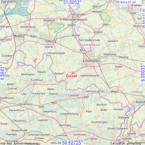
Duizel GPS coordinates[2]
51° 22' 5.988" North, 5° 17' 49.992" East
| Map corner | latitude | longitude |
|---|---|---|
| Upper-left | 51.8052°, | 4.5941° |
| Center: | 51.36833°, | 5.29722° |
| Lower-right: | 50.92725°, | 6.00035° |
| Map W x H: | 97.6×97.6 km | = 60.6×60.6mi |
| max Lat: | 53.48025° ⇑87.4% North |
| Duizel: | 51.36833° |
| min Lat: | ⇓12.6% South 50.76917° |
| min Long | Duizel | max Long |
| 3.38611° | 5.29722° | 7.16528° |
| W 36.5%⇐ | ⇒63.5% E |
Elevation
Elevation of Duizel is 29 m = 95 ft, and this is 14 m = 46 ft above average elevation for this country.
| Max E: |
203 m = 666 ft | 12.8% |
| Duizel | 29 m 95 ft | |
| Avg. | 15 m = 49 ft | |
Min E: |
-6 m = -20 ft | 87.2% |
See also: Netherlands elevation on elevation.city.
Geographical zone
Duizel is located in North temperate zone (between Tropic of Cancer and the Arctic Circle). Distance of this North polar circle is 1689.6 km =1049.9 mi to North.| Distance of | km | miles | from Duizel |
|---|---|---|---|
| North Pole | 4295.4 | 2669 | to North |
| Arctic Circle | 1689.6 | 1049.9 | to North |
| Tropic Cancer | 3105.7 | 1929.8 | to South |
| Equator | 5711.6 | 3549 | to South |


Nearby cities:
15 places around Duizel: (largest is in red/bold)
• Bergeijk
6.9 km =4.3 mi,  142°
142°
• Bladel
5.3 km =3.3 mi,  270°
270°
• Casteren
5.2 km =3.2 mi,  307°
307°
• Eersel
1.9 km =1.2 mi,  129°
129°
• Hapert
2.8 km =1.7 mi, 270°
• Hoogeloon
3.8 km =2.4 mi,  328°
328°
• Hulsel
8.6 km =5.3 mi,  285°
285°
• Luyksgestel
9 km =5.6 mi,  168°
168°
• Netersel
7.3 km =4.5 mi,  302°
302°
• Oerle
7.9 km =4.9 mi,  40°
40°
• Riethoven
6.5 km =4 mi,  104°
104°
• Steensel
4 km =2.5 mi,  76°
76°
• Weebosch
6.7 km =4.2 mi,  181°
181°
• Westerhoven
7.9 km =4.9 mi,  120°
120°
• Zonderwijk
8.2 km =5.1 mi,  54°
54°
Sources, notices
• [Note1] Compared only with cities in Netherlands existing in our database
• [Src1] Map data: © OpenStreetMap contributors (CC-BY-SA)
• [Src2] Other city data from geonames.org with taken over terms of usage.
• [Src3] Geographical zone / Annual Mean Temperature by Robert A. Rohde @ Wikipedia
