Siegerswoude geodata
Siegerswoude (Friesland) is a populated place; located in Netherlands in Europe/Amsterdam (GMT+2) time zone. With population of 830 people, there are 1506 cities with bigger population in this country. Compared to other cities in Netherlands, 88.9% of cities are located further ↓South; 84.4% of cities are located further ←West and 58.8% of cities have higher elevation than Siegerswoude. Note1


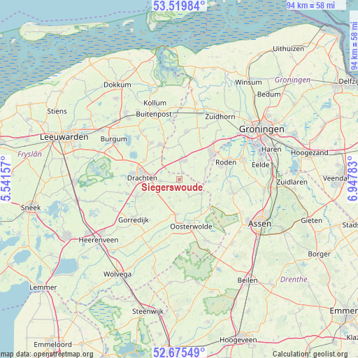
Siegerswoude GPS coordinates[2]
53° 5' 59.064" North, 6° 14' 40.92" East
| Map corner | latitude | longitude |
|---|---|---|
| Upper-left | 53.51984°, | 5.54157° |
| Center: | 53.09974°, | 6.2447° |
| Lower-right: | 52.67549°, | 6.94783° |
| Map W x H: | 93.9×93.9 km | = 58.3×58.3mi |
| max Lat: | 53.48025° ⇑11.1% North |
| Siegerswoude: | 53.09974° |
| min Lat: | ⇓88.9% South 50.76917° |
| min Long | Siegerswoude | max Long |
| 3.38611° | 6.2447° | 7.16528° |
| W 84.4%⇐ | ⇒15.6% E |
Elevation
Elevation of Siegerswoude is 4 m = 13 ft, and this is 11 m = 36 ft below average elevation for this country.
| Max E: |
203 m = 666 ft | 58.8% |
| Avg. | 15 m = 49 ft | |
| Siegerswoude | 4 m = 13 ft | |
Min E: |
-6 m = -20 ft | 41.2% |
See also: Netherlands elevation on elevation.city.
Geographical zone
Siegerswoude is located in North temperate zone (between Tropic of Cancer and the Arctic Circle). Distance of this North polar circle is 1497 km =930.2 mi to North.| Distance of | km | miles | from Siegerswoude |
|---|---|---|---|
| North Pole | 4102.9 | 2549.4 | to North |
| Arctic Circle | 1497 | 930.2 | to North |
| Tropic Cancer | 3298.2 | 2049.4 | to South |
| Equator | 5904.1 | 3668.6 | to South |


Nearby cities:
15 places around Siegerswoude: (largest is in red/bold)
• Bakkeveen
2.3 km =1.4 mi,  159°
159°
• Boelenslaan
9.6 km =6 mi,  315°
315°
• Donkerbroek
9.2 km =5.7 mi,  182°
182°
• Drachten
9.8 km =6.1 mi,  278°
278°
• Drachtstercompagnie
7.9 km =4.9 mi,  299°
299°
• Frieschepalen
2.8 km =1.7 mi,  292°
292°
• Haulerwijk
7.2 km =4.5 mi,  123°
123°
• Houtigehage
8.8 km =5.5 mi,  311°
311°
• Kornhorn
9.1 km =5.7 mi,  359°
359°
• Marum
5.1 km =3.2 mi,  13°
13°
• Niebert
8.8 km =5.5 mi,  39°
39°
• Nuis
7 km =4.3 mi, 35°
• Ureterp
5.2 km =3.2 mi,  261°
261°
• Waskemeer
5.3 km =3.3 mi,  153°
153°
• Wijnjewoude
5.3 km =3.3 mi,  210°
210°
Sources, notices
• [Note1] Compared only with cities in Netherlands existing in our database
• [Src1] Map data: © OpenStreetMap contributors (CC-BY-SA)
• [Src2] Other city data from geonames.org with taken over terms of usage.
• [Src3] Geographical zone / Annual Mean Temperature by Robert A. Rohde @ Wikipedia
