Marum geodata
Marum (Groningen) is a populated place; located in Netherlands in Europe/Amsterdam (GMT+2) time zone. With population of 5,170 people, there are 467 cities with bigger population in this country. Compared to other cities in Netherlands, 90.1% of cities are located further ↓South; 84.9% of cities are located further ←West and 58.8% of cities have higher elevation than Marum. Note1


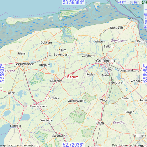
Marum GPS coordinates[2]
53° 8' 39.012" North, 6° 15' 45" East
| Map corner | latitude | longitude |
|---|---|---|
| Upper-left | 53.56384°, | 5.55937° |
| Center: | 53.14417°, | 6.2625° |
| Lower-right: | 52.72036°, | 6.96562° |
| Map W x H: | 93.8×93.8 km | = 58.3×58.3mi |
| max Lat: | 53.48025° ⇑9.9% North |
| Marum: | 53.14417° |
| min Lat: | ⇓90.1% South 50.76917° |
| min Long | Marum | max Long |
| 3.38611° | 6.2625° | 7.16528° |
| W 84.9%⇐ | ⇒15.1% E |
Elevation
Elevation of Marum is 4 m = 13 ft, and this is 11 m = 36 ft below average elevation for this country.
| Max E: |
203 m = 666 ft | 58.8% |
| Avg. | 15 m = 49 ft | |
| Marum | 4 m = 13 ft | |
Min E: |
-6 m = -20 ft | 41.2% |
See also: Netherlands elevation on elevation.city.
Geographical zone
Marum is located in North temperate zone (between Tropic of Cancer and the Arctic Circle). Distance of this North polar circle is 1492.1 km =927.1 mi to North.| Distance of | km | miles | from Marum |
|---|---|---|---|
| North Pole | 4098 | 2546.4 | to North |
| Arctic Circle | 1492.1 | 927.1 | to North |
| Tropic Cancer | 3303.2 | 2052.5 | to South |
| Equator | 5909.1 | 3671.7 | to South |


Nearby cities:
15 places around Marum: (largest is in red/bold)
• Bakkeveen
7.1 km =4.4 mi,  183°
183°
• Boelenslaan
8.1 km =5 mi,  283°
283°
• Diepswal
7.2 km =4.5 mi,  84°
84°
• Doezum
6.4 km =4 mi,  351°
351°
• Drachtstercompagnie
8.1 km =5 mi,  262°
262°
• Frieschepalen
5.4 km =3.4 mi,  224°
224°
• Grootegast
7.6 km =4.7 mi,  5°
5°
• Houtigehage
7.9 km =4.9 mi, 276°
• Kornhorn
4.4 km =2.7 mi,  342°
342°
• Leek
7.9 km =4.9 mi,  74°
74°
• Niebert
4.7 km =2.9 mi, 66°
• Nuis
3 km =1.9 mi, 75°
• Siegerswoude
5.1 km =3.2 mi,  193°
193°
• Surhuisterveen
7.6 km =4.7 mi,  306°
306°
• Ureterp
8.6 km =5.3 mi,  227°
227°
Sources, notices
• [Note1] Compared only with cities in Netherlands existing in our database
• [Src1] Map data: © OpenStreetMap contributors (CC-BY-SA)
• [Src2] Other city data from geonames.org with taken over terms of usage.
• [Src3] Geographical zone / Annual Mean Temperature by Robert A. Rohde @ Wikipedia
