Donkerbroek geodata
Donkerbroek (Friesland) is a populated place; located in Netherlands in Europe/Amsterdam (GMT+2) time zone. With population of 1,140 people, there are 1307 cities with bigger population in this country. Compared to other cities in Netherlands, 86% of cities are located further ↓South; 84.3% of cities are located further ←West and 54.1% of cities have higher elevation than Donkerbroek. Note1


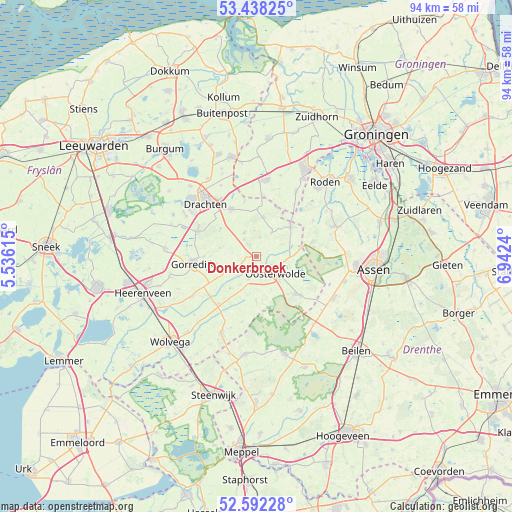
Donkerbroek GPS coordinates[2]
53° 1' 2.424" North, 6° 14' 21.372" East
| Map corner | latitude | longitude |
|---|---|---|
| Upper-left | 53.43825°, | 5.53615° |
| Center: | 53.01734°, | 6.23927° |
| Lower-right: | 52.59228°, | 6.9424° |
| Map W x H: | 94.1×94.1 km | = 58.5×58.5mi |
| max Lat: | 53.48025° ⇑14% North |
| Donkerbroek: | 53.01734° |
| min Lat: | ⇓86% South 50.76917° |
| min Long | Donkerbroek | max Long |
| 3.38611° | 6.23927° | 7.16528° |
| W 84.3%⇐ | ⇒15.7% E |
Elevation
Elevation of Donkerbroek is 5 m = 16 ft, and this is 10 m = 33 ft below average elevation for this country.
| Max E: |
203 m = 666 ft | 54.1% |
| Avg. | 15 m = 49 ft | |
| Donkerbroek | 5 m = 16 ft | |
Min E: |
-6 m = -20 ft | 45.9% |
See also: Netherlands elevation on elevation.city.
Geographical zone
Donkerbroek is located in North temperate zone (between Tropic of Cancer and the Arctic Circle). Distance of this North polar circle is 1506.2 km =935.9 mi to North.| Distance of | km | miles | from Donkerbroek |
|---|---|---|---|
| North Pole | 4112.1 | 2555.1 | to North |
| Arctic Circle | 1506.2 | 935.9 | to North |
| Tropic Cancer | 3289.1 | 2043.8 | to South |
| Equator | 5895 | 3663 | to South |


Nearby cities:
15 places around Donkerbroek: (largest is in red/bold)
• Appelscha
10.2 km =6.3 mi,  132°
132°
• Bakkeveen
7.1 km =4.4 mi,  9°
9°
• Frieschepalen
10.5 km =6.5 mi,  347°
347°
• Haulerwijk
8.3 km =5.2 mi,  50°
50°
• Hoornsterzwaag
4.9 km =3 mi,  244°
244°
• Jubbega
8 km =5 mi,  259°
259°
• Lippenhuizen
9.8 km =6.1 mi,  270°
270°
• Makkinga
4.3 km =2.7 mi,  199°
199°
• Oldeberkoop
11.4 km =7.1 mi,  219°
219°
• Oosterwolde
4.5 km =2.8 mi, 129°
• Siegerswoude
9.2 km =5.7 mi,  2°
2°
• Ureterp
9.6 km =6 mi,  330°
330°
• Veenhuizen
10.6 km =6.6 mi,  81°
81°
• Waskemeer
5.2 km =3.2 mi,  31°
31°
• Wijnjewoude
5.1 km =3.2 mi, 333°
Sources, notices
• [Note1] Compared only with cities in Netherlands existing in our database
• [Src1] Map data: © OpenStreetMap contributors (CC-BY-SA)
• [Src2] Other city data from geonames.org with taken over terms of usage.
• [Src3] Geographical zone / Annual Mean Temperature by Robert A. Rohde @ Wikipedia
