's-Hertogenbosch geodata
's-Hertogenbosch (North Brabant) is a seat of a first-order administrative division; located in Netherlands in Europe/Amsterdam (GMT+2) time zone. With population of 134,520 people, there are 16 cities with bigger population in this country. Compared to other cities in Netherlands, 68.9% of cities are located further ↑North; 63.3% of cities are located further →East and 52.4% of cities have lower elevation than 's-Hertogenbosch. Note1


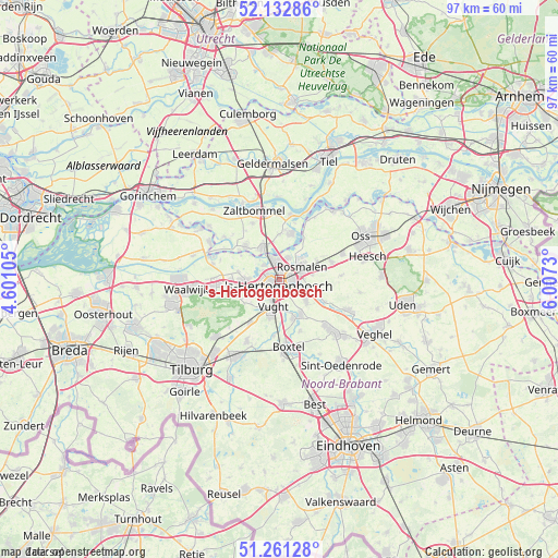
's-Hertogenbosch GPS coordinates[2]
51° 41' 57.012" North, 5° 18' 15.012" East
| Map corner | latitude | longitude |
|---|---|---|
| Upper-left | 52.13286°, | 4.60105° |
| Center: | 51.69917°, | 5.30417° |
| Lower-right: | 51.26128°, | 6.0073° |
| Map W x H: | 96.9×96.9 km | = 60.2×60.2mi |
| max Lat: | 53.48025° ⇑68.9% North |
| 's-Hertogenbosch: | 51.69917° |
| min Lat: | ⇓31.1% South 50.76917° |
| min Long | 's-Hertogenbosc | max Long |
| 3.38611° | 5.30417° | 7.16528° |
| W 36.7%⇐ | ⇒63.3% E |
Elevation
Elevation of 's-Hertogenbosch is 7 m = 23 ft, and this is 8 m = 26 ft below average elevation for this country.
| Max E: |
203 m = 666 ft | 47.6% |
| Avg. | 15 m = 49 ft | |
| 's-Hertogenbosch | 7 m = 23 ft | |
Min E: |
-6 m = -20 ft | 52.4% |
See also: 's-Hertogenbosch elevation on elevation.city.
Geographical zone
's-Hertogenbosch is located in North temperate zone (between Tropic of Cancer and the Arctic Circle). Distance of this North polar circle is 1652.8 km =1027 mi to North.| Distance of | km | miles | from 's-Hertogenbosch |
|---|---|---|---|
| North Pole | 4258.7 | 2646.2 | to North |
| Arctic Circle | 1652.8 | 1027 | to North |
| Tropic Cancer | 3142.5 | 1952.7 | to South |
| Equator | 5748.4 | 3571.9 | to South |


Nearby cities:
15 places around 's-Hertogenbosch: (largest is in red/bold)
• Berlicum
7 km =4.3 mi,  110°
110°
• Cromvoirt
6.6 km =4.1 mi,  229°
229°
• De Kruiskamp
3 km =1.9 mi,  271°
271°
• De Rompert
2.1 km =1.3 mi,  23°
23°
• Den Dungen
6 km =3.7 mi,  129°
129°
• Deuteren
2.9 km =1.8 mi,  241°
241°
• Haarsteeg
7.4 km =4.6 mi,  280°
280°
• Hedel
6.2 km =3.9 mi,  331°
331°
• Kruisstraat
7.2 km =4.5 mi,  59°
59°
• Maaskantje
6.5 km =4 mi, 134°
• Molenhoek
4.6 km =2.9 mi,  73°
73°
• Orthen
0.8 km =0.5 mi,  2°
2°
• Sint-Michielsgestel
7.2 km =4.5 mi,  152°
152°
• Theereheide
7.1 km =4.4 mi,  161°
161°
• Vught
5.2 km =3.2 mi,  192°
192°
In other languages:
- In Spanish: Bolduque
- In France: Bois-le-Duc
- In German: Herzogenbusch
- In Italian: Boscoducale
- In Russian: Хертогенбос
Sources, notices
• [Note1] Compared only with cities in Netherlands existing in our database
• [Src1] Map data: © OpenStreetMap contributors (CC-BY-SA)
• [Src2] Other city data from geonames.org with taken over terms of usage.
• [Src3] Geographical zone / Annual Mean Temperature by Robert A. Rohde @ Wikipedia
