Cromvoirt geodata
Cromvoirt (North Brabant) is a populated place; located in Netherlands in Europe/Amsterdam (GMT+2) time zone. With population of 700 people, there are 1626 cities with bigger population in this country. Compared to other cities in Netherlands, 70.8% of cities are located further ↑North; 65.7% of cities are located further →East and 55.1% of cities have lower elevation than Cromvoirt. Note1


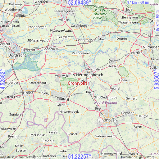
Cromvoirt GPS coordinates[2]
51° 39' 38.988" North, 5° 13' 54.984" East
| Map corner | latitude | longitude |
|---|---|---|
| Upper-left | 52.09489°, | 4.52882° |
| Center: | 51.66083°, | 5.23194° |
| Lower-right: | 51.22257°, | 5.93507° |
| Map W x H: | 97×97 km | = 60.3×60.3mi |
| max Lat: | 53.48025° ⇑70.8% North |
| Cromvoirt: | 51.66083° |
| min Lat: | ⇓29.2% South 50.76917° |
| min Long | Cromvoirt | max Long |
| 3.38611° | 5.23194° | 7.16528° |
| W 34.3%⇐ | ⇒65.7% E |
Elevation
Elevation of Cromvoirt is 8 m = 26 ft, and this is 7 m = 23 ft below average elevation for this country.
| Max E: |
203 m = 666 ft | 44.9% |
| Avg. | 15 m = 49 ft | |
| Cromvoirt | 8 m = 26 ft | |
Min E: |
-6 m = -20 ft | 55.1% |
See also: Netherlands elevation on elevation.city.
Geographical zone
Cromvoirt is located in North temperate zone (between Tropic of Cancer and the Arctic Circle). Distance of this North polar circle is 1657 km =1029.6 mi to North.| Distance of | km | miles | from Cromvoirt |
|---|---|---|---|
| North Pole | 4262.9 | 2648.8 | to North |
| Arctic Circle | 1657 | 1029.6 | to North |
| Tropic Cancer | 3138.2 | 1950 | to South |
| Equator | 5744.1 | 3569.2 | to South |


Nearby cities:
15 places around Cromvoirt: (largest is in red/bold)
• 's-Hertogenbosch
6.6 km =4.1 mi,  49°
49°
• Biezenmortel
5.5 km =3.4 mi,  222°
222°
• De Kruiskamp
4.8 km =3 mi,  24°
24°
• Deuteren
3.7 km =2.3 mi,  39°
39°
• Elshout
7.6 km =4.7 mi,  305°
305°
• Esch
6.9 km =4.3 mi,  144°
144°
• Haaren
6.5 km =4 mi,  185°
185°
• Haarsteeg
6.1 km =3.8 mi,  337°
337°
• Helvoirt
3.2 km =2 mi,  181°
181°
• Nieuwkuijk
4.7 km =2.9 mi, 313°
• Orthen
7.1 km =4.4 mi, 44°
• Theereheide
7.7 km =4.8 mi,  108°
108°
• Udenhout
8.4 km =5.2 mi,  226°
226°
• Vliedberg
4.3 km =2.7 mi,  318°
318°
• Vught
3.9 km =2.4 mi,  102°
102°
Sources, notices
• [Note1] Compared only with cities in Netherlands existing in our database
• [Src1] Map data: © OpenStreetMap contributors (CC-BY-SA)
• [Src2] Other city data from geonames.org with taken over terms of usage.
• [Src3] Geographical zone / Annual Mean Temperature by Robert A. Rohde @ Wikipedia
