Schoonrewoerd geodata
Schoonrewoerd (Utrecht) is a populated place; located in Netherlands in Europe/Amsterdam (GMT+2) time zone. With population of 1,595 people, there are 1084 cities with bigger population in this country. Compared to other cities in Netherlands, 56.2% of cities are located further ↑North; 69.5% of cities are located further →East and 65.8% of cities have higher elevation than Schoonrewoerd. Note1


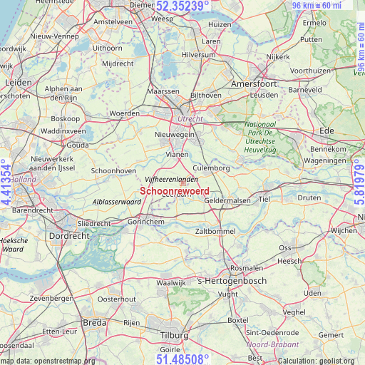
Schoonrewoerd GPS coordinates[2]
51° 55' 14.988" North, 5° 7' 0.012" East
| Map corner | latitude | longitude |
|---|---|---|
| Upper-left | 52.35239°, | 4.41354° |
| Center: | 51.92083°, | 5.11667° |
| Lower-right: | 51.48508°, | 5.81979° |
| Map W x H: | 96.4×96.4 km | = 59.9×59.9mi |
| max Lat: | 53.48025° ⇑56.2% North |
| Schoonrewoerd: | 51.92083° |
| min Lat: | ⇓43.8% South 50.76917° |
| min Long | Schoonrewoerd | max Long |
| 3.38611° | 5.11667° | 7.16528° |
| W 30.5%⇐ | ⇒69.5% E |
Elevation
Elevation of Schoonrewoerd is 3 m = 10 ft, and this is 12 m = 39 ft below average elevation for this country.
| Max E: |
203 m = 666 ft | 65.8% |
| Avg. | 15 m = 49 ft | |
| Schoonrewoerd | 3 m = 10 ft | |
Min E: |
-6 m = -20 ft | 34.2% |
See also: Netherlands elevation on elevation.city.
Geographical zone
Schoonrewoerd is located in North temperate zone (between Tropic of Cancer and the Arctic Circle). Distance of this North polar circle is 1628.1 km =1011.7 mi to North.| Distance of | km | miles | from Schoonrewoerd |
|---|---|---|---|
| North Pole | 4234 | 2630.9 | to North |
| Arctic Circle | 1628.1 | 1011.7 | to North |
| Tropic Cancer | 3167.1 | 1967.9 | to South |
| Equator | 5773.1 | 3587.2 | to South |


Nearby cities:
15 places around Schoonrewoerd: (largest is in red/bold)
• Beesd
6.3 km =3.9 mi,  125°
125°
• Culemborg
8.5 km =5.3 mi,  63°
63°
• De Hagen
8.2 km =5.1 mi,  353°
353°
• Deil
9.6 km =6 mi,  115°
115°
• Everdingen
5.6 km =3.5 mi,  28°
28°
• Hagestein
6.7 km =4.2 mi,  3°
3°
• Kedichem
8.2 km =5.1 mi,  214°
214°
• Leerdam
3.5 km =2.2 mi, 209°
• Lopikerkapel
9.3 km =5.8 mi,  328°
328°
• Rhenoy
4.9 km =3 mi,  149°
149°
• Rumpt
5.8 km =3.6 mi, 134°
• Uitweg
9.7 km =6 mi,  315°
315°
• Vianen
8.2 km =5.1 mi, 347°
• Vreeswijk
10.1 km =6.3 mi, 350°
• Zijderveld
2.8 km =1.7 mi, 34°
Sources, notices
• [Note1] Compared only with cities in Netherlands existing in our database
• [Src1] Map data: © OpenStreetMap contributors (CC-BY-SA)
• [Src2] Other city data from geonames.org with taken over terms of usage.
• [Src3] Geographical zone / Annual Mean Temperature by Robert A. Rohde @ Wikipedia
