Schilberg geodata
Schilberg (Limburg) is a section of populated place; located in Netherlands in Europe/Amsterdam (GMT+2) time zone. With population of 1,960 people, there are 972 cities with bigger population in this country. Compared to other cities in Netherlands, 92.5% of cities are located further ↑North; 63.3% of cities are located further ←West and 89.2% of cities have lower elevation than Schilberg. Note1


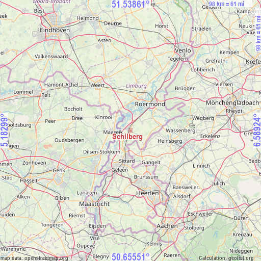
Schilberg GPS coordinates[2]
51° 5' 57.012" North, 5° 53' 9.996" East
| Map corner | latitude | longitude |
|---|---|---|
| Upper-left | 51.53861°, | 5.18299° |
| Center: | 51.09917°, | 5.88611° |
| Lower-right: | 50.65551°, | 6.58924° |
| Map W x H: | 98.2×98.2 km | = 61×61mi |
| max Lat: | 53.48025° ⇑92.5% North |
| Schilberg: | 51.09917° |
| min Lat: | ⇓7.5% South 50.76917° |
| min Long | Schilberg | max Long |
| 3.38611° | 5.88611° | 7.16528° |
| W 63.3%⇐ | ⇒36.7% E |
Elevation
Elevation of Schilberg is 32 m = 105 ft, and this is 17 m = 56 ft above average elevation for this country.
| Max E: |
203 m = 666 ft | 10.8% |
| Schilberg | 32 m 105 ft | |
| Avg. | 15 m = 49 ft | |
Min E: |
-6 m = -20 ft | 89.2% |
See also: Netherlands elevation on elevation.city.
Geographical zone
Schilberg is located in North temperate zone (between Tropic of Cancer and the Arctic Circle). Distance of this North polar circle is 1719.5 km =1068.4 mi to North.| Distance of | km | miles | from Schilberg |
|---|---|---|---|
| North Pole | 4325.4 | 2687.7 | to North |
| Arctic Circle | 1719.5 | 1068.4 | to North |
| Tropic Cancer | 3075.8 | 1911.2 | to South |
| Equator | 5681.7 | 3530.4 | to South |


Nearby cities:
15 places around Schilberg: (largest is in red/bold)
• Brachterbeek
5.5 km =3.4 mi,  13°
13°
• Dieteren
3.8 km =2.4 mi,  228°
228°
• Heide
3.6 km =2.2 mi,  195°
195°
• Hingen
1.1 km =0.7 mi,  53°
53°
• Holtum
7.3 km =4.5 mi,  217°
217°
• Koningsbosch
7.3 km =4.5 mi,  136°
136°
• Linne
7.2 km =4.5 mi,  30°
30°
• Maasbracht
4.5 km =2.8 mi,  0°
0°
• Montfort
5.3 km =3.3 mi,  55°
55°
• Peij
0.9 km =0.6 mi,  129°
129°
• Roosteren
5.1 km =3.2 mi,  249°
249°
• Sint Joost
2.2 km =1.4 mi,  23°
23°
• Slek
1.5 km =0.9 mi,  194°
194°
• Thorn
7.6 km =4.7 mi,  335°
335°
• Wessem
6.7 km =4.2 mi,  357°
357°
Sources, notices
• [Note1] Compared only with cities in Netherlands existing in our database
• [Src1] Map data: © OpenStreetMap contributors (CC-BY-SA)
• [Src2] Other city data from geonames.org with taken over terms of usage.
• [Src3] Geographical zone / Annual Mean Temperature by Robert A. Rohde @ Wikipedia
