Holtum geodata
Holtum (Limburg) is a populated place; located in Netherlands in Europe/Amsterdam (GMT+2) time zone. With population of 1,170 people, there are 1297 cities with bigger population in this country. Compared to other cities in Netherlands, 92.9% of cities are located further ↑North; 59.2% of cities are located further ←West and 88.5% of cities have lower elevation than Holtum. Note1


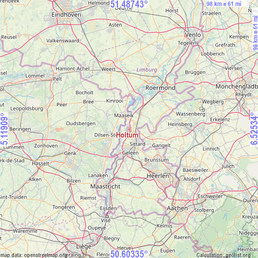
Holtum GPS coordinates[2]
51° 2' 51" North, 5° 49' 19.992" East
| Map corner | latitude | longitude |
|---|---|---|
| Upper-left | 51.48743°, | 5.11909° |
| Center: | 51.0475°, | 5.82222° |
| Lower-right: | 50.60335°, | 6.52534° |
| Map W x H: | 98.3×98.3 km | = 61.1×61.1mi |
| max Lat: | 53.48025° ⇑92.9% North |
| Holtum: | 51.0475° |
| min Lat: | ⇓7.1% South 50.76917° |
| min Long | Holtum | max Long |
| 3.38611° | 5.82222° | 7.16528° |
| W 59.2%⇐ | ⇒40.8% E |
Elevation
Elevation of Holtum is 31 m = 102 ft, and this is 16 m = 52 ft above average elevation for this country.
| Max E: |
203 m = 666 ft | 11.5% |
| Holtum | 31 m 102 ft | |
| Avg. | 15 m = 49 ft | |
Min E: |
-6 m = -20 ft | 88.5% |
See also: Netherlands elevation on elevation.city.
Geographical zone
Holtum is located in North temperate zone (between Tropic of Cancer and the Arctic Circle). Distance of this North polar circle is 1725.2 km =1072 mi to North.| Distance of | km | miles | from Holtum |
|---|---|---|---|
| North Pole | 4331.1 | 2691.2 | to North |
| Arctic Circle | 1725.2 | 1072 | to North |
| Tropic Cancer | 3070 | 1907.6 | to South |
| Equator | 5675.9 | 3526.8 | to South |


Nearby cities:
15 places around Holtum: (largest is in red/bold)
• Berg
6 km =3.7 mi,  216°
216°
• Born
2 km =1.2 mi,  206°
206°
• Buchten
1 km =0.6 mi,  242°
242°
• Dieteren
3.6 km =2.2 mi,  26°
26°
• Einighausen
5.1 km =3.2 mi,  175°
175°
• Grevenbicht
3.5 km =2.2 mi,  252°
252°
• Guttecoven
3.6 km =2.2 mi, 184°
• Heide
4.2 km =2.6 mi,  56°
56°
• Limbricht
4.1 km =2.5 mi,  164°
164°
• Obbicht
3.6 km =2.2 mi,  233°
233°
• Overhoven
5.3 km =3.3 mi,  144°
144°
• Papenhoven
3.2 km =2 mi,  261°
261°
• Roosteren
4 km =2.5 mi,  355°
355°
• Slek
5.9 km =3.7 mi,  43°
43°
• Stadbroek
6.3 km =3.9 mi, 143°
Sources, notices
• [Note1] Compared only with cities in Netherlands existing in our database
• [Src1] Map data: © OpenStreetMap contributors (CC-BY-SA)
• [Src2] Other city data from geonames.org with taken over terms of usage.
• [Src3] Geographical zone / Annual Mean Temperature by Robert A. Rohde @ Wikipedia
