Biezenmortel geodata
Biezenmortel (North Brabant) is a populated place; located in Netherlands in Europe/Amsterdam (GMT+2) time zone. With population of 715 people, there are 1609 cities with bigger population in this country. Compared to other cities in Netherlands, 72.7% of cities are located further ↑North; 67.1% of cities are located further →East and 59.4% of cities have lower elevation than Biezenmortel. Note1


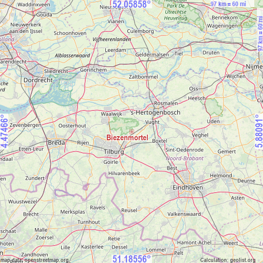
Biezenmortel GPS coordinates[2]
51° 37' 27.012" North, 5° 10' 40.008" East
| Map corner | latitude | longitude |
|---|---|---|
| Upper-left | 52.05858°, | 4.47466° |
| Center: | 51.62417°, | 5.17778° |
| Lower-right: | 51.18556°, | 5.88091° |
| Map W x H: | 97.1×97.1 km | = 60.3×60.3mi |
| max Lat: | 53.48025° ⇑72.7% North |
| Biezenmortel: | 51.62417° |
| min Lat: | ⇓27.3% South 50.76917° |
| min Long | Biezenmortel | max Long |
| 3.38611° | 5.17778° | 7.16528° |
| W 32.9%⇐ | ⇒67.1% E |
Elevation
Elevation of Biezenmortel is 10 m = 33 ft, and this is 5 m = 16 ft below average elevation for this country.
| Max E: |
203 m = 666 ft | 40.6% |
| Avg. | 15 m = 49 ft | |
| Biezenmortel | 10 m = 33 ft | |
Min E: |
-6 m = -20 ft | 59.4% |
See also: Netherlands elevation on elevation.city.
Geographical zone
Biezenmortel is located in North temperate zone (between Tropic of Cancer and the Arctic Circle). Distance of this North polar circle is 1661.1 km =1032.2 mi to North.| Distance of | km | miles | from Biezenmortel |
|---|---|---|---|
| North Pole | 4267 | 2651.4 | to North |
| Arctic Circle | 1661.1 | 1032.2 | to North |
| Tropic Cancer | 3134.2 | 1947.5 | to South |
| Equator | 5740.1 | 3566.7 | to South |


Nearby cities:
15 places around Biezenmortel: (largest is in red/bold)
• Cromvoirt
5.5 km =3.4 mi,  42°
42°
• Elshout
8.9 km =5.5 mi,  343°
343°
• Enschot
5.7 km =3.5 mi,  207°
207°
• Esch
7.9 km =4.9 mi,  100°
100°
• Groeseind
8.3 km =5.2 mi,  229°
229°
• Haaren
3.9 km =2.4 mi,  128°
128°
• Helvoirt
3.7 km =2.3 mi,  77°
77°
• Loon op Zand
7.1 km =4.4 mi,  272°
272°
• Loven
8.6 km =5.3 mi,  220°
220°
• Nieuwkuijk
7.3 km =4.5 mi,  2°
2°
• Oisterwijk
5.1 km =3.2 mi,  171°
171°
• Quirijnstok
7.1 km =4.4 mi, 231°
• Udenhout
2.9 km =1.8 mi,  235°
235°
• Vliedberg
7.3 km =4.5 mi,  6°
6°
• Vught
8.2 km =5.1 mi,  66°
66°
Sources, notices
• [Note1] Compared only with cities in Netherlands existing in our database
• [Src1] Map data: © OpenStreetMap contributors (CC-BY-SA)
• [Src2] Other city data from geonames.org with taken over terms of usage.
• [Src3] Geographical zone / Annual Mean Temperature by Robert A. Rohde @ Wikipedia
