Lichtenberg geodata
Lichtenberg (Limburg) is a section of populated place; located in Netherlands in Europe/Amsterdam (GMT+2) time zone. With population of 1,635 people, there are 1064 cities with bigger population in this country. Compared to other cities in Netherlands, 96.2% of cities are located further ↑North; 74.5% of cities are located further ←West and 99.5% of cities have lower elevation than Lichtenberg. Note1


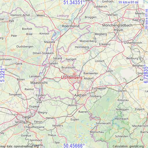
Lichtenberg GPS coordinates[2]
50° 54' 7.92" North, 6° 1' 30.828" East
| Map corner | latitude | longitude |
|---|---|---|
| Upper-left | 51.34351°, | 5.3221° |
| Center: | 50.9022°, | 6.02523° |
| Lower-right: | 50.45666°, | 6.72835° |
| Map W x H: | 98.6×98.6 km | = 61.3×61.3mi |
| max Lat: | 53.48025° ⇑96.2% North |
| Lichtenberg: | 50.9022° |
| min Lat: | ⇓3.8% South 50.76917° |
| min Long | Lichtenberg | max Long |
| 3.38611° | 6.02523° | 7.16528° |
| W 74.5%⇐ | ⇒25.5% E |
Elevation
Elevation of Lichtenberg is 164 m = 538 ft, and this is 149 m = 489 ft above average elevation for this country.
| Max E: |
203 m = 666 ft | 0.5% |
| Lichtenberg | 164 m 538 ft | |
| Avg. | 15 m = 49 ft | |
Min E: |
-6 m = -20 ft | 99.5% |
See also: Netherlands elevation on elevation.city.
Geographical zone
Lichtenberg is located in North temperate zone (between Tropic of Cancer and the Arctic Circle). Distance of this North polar circle is 1741.4 km =1082.1 mi to North.| Distance of | km | miles | from Lichtenberg |
|---|---|---|---|
| North Pole | 4347.3 | 2701.3 | to North |
| Arctic Circle | 1741.4 | 1082.1 | to North |
| Tropic Cancer | 3053.9 | 1897.6 | to South |
| Equator | 5659.8 | 3516.8 | to South |


Nearby cities:
15 places around Lichtenberg: (largest is in red/bold)
• Abdissenbosch
1.7 km =1.1 mi,  19°
19°
• Beersdal
4.3 km =2.7 mi,  275°
275°
• Chevremont
3.8 km =2.4 mi,  140°
140°
• Groenstraat
1.9 km =1.2 mi,  63°
63°
• Haanrade
4.2 km =2.6 mi,  125°
125°
• Heerlen
3.7 km =2.3 mi,  236°
236°
• Heksenberg
4.2 km =2.6 mi,  299°
299°
• Hopel
2.1 km =1.3 mi,  121°
121°
• Kaalheide
4.2 km =2.6 mi,  169°
169°
• Kakert
1.5 km =0.9 mi, 278°
• Lauradorp
1.8 km =1.1 mi,  52°
52°
• Meezenbroek
2.5 km =1.6 mi,  256°
256°
• Palemig
2.9 km =1.8 mi,  272°
272°
• Terwinselen
4 km =2.5 mi,  180°
180°
• Waubach
2.5 km =1.6 mi,  44°
44°
Sources, notices
• [Note1] Compared only with cities in Netherlands existing in our database
• [Src1] Map data: © OpenStreetMap contributors (CC-BY-SA)
• [Src2] Other city data from geonames.org with taken over terms of usage.
• [Src3] Geographical zone / Annual Mean Temperature by Robert A. Rohde @ Wikipedia
