Heerlen geodata
Heerlen (Limburg) is a populated place; located in Netherlands in Europe/Amsterdam (GMT+2) time zone. With population of 93,084 people, there are 26 cities with bigger population in this country. Compared to other cities in Netherlands, 96.7% of cities are located further ↑North; 71.3% of cities are located further ←West and 97.9% of cities have lower elevation than Heerlen. Note1


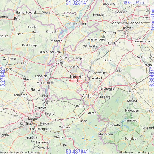
Heerlen GPS coordinates[2]
50° 53' 1.14" North, 5° 58' 53.544" East
| Map corner | latitude | longitude |
|---|---|---|
| Upper-left | 51.32514°, | 5.27842° |
| Center: | 50.88365°, | 5.98154° |
| Lower-right: | 50.43794°, | 6.68467° |
| Map W x H: | 98.6×98.6 km | = 61.3×61.3mi |
| max Lat: | 53.48025° ⇑96.7% North |
| Heerlen: | 50.88365° |
| min Lat: | ⇓3.3% South 50.76917° |
| min Long | Heerlen | max Long |
| 3.38611° | 5.98154° | 7.16528° |
| W 71.3%⇐ | ⇒28.7% E |
Elevation
Elevation of Heerlen is 114 m = 374 ft, and this is 99 m = 325 ft above average elevation for this country.
| Max E: |
203 m = 666 ft | 2.1% |
| Heerlen | 114 m 374 ft | |
| Avg. | 15 m = 49 ft | |
Min E: |
-6 m = -20 ft | 97.9% |
See also: Heerlen elevation on elevation.city.
Geographical zone
Heerlen is located in North temperate zone (between Tropic of Cancer and the Arctic Circle). Distance of this North polar circle is 1743.4 km =1083.3 mi to North.| Distance of | km | miles | from Heerlen |
|---|---|---|---|
| North Pole | 4349.3 | 2702.5 | to North |
| Arctic Circle | 1743.4 | 1083.3 | to North |
| Tropic Cancer | 3051.8 | 1896.3 | to South |
| Equator | 5657.7 | 3515.5 | to South |


Nearby cities:
15 places around Heerlen: (largest is in red/bold)
• Beersdal
2.8 km =1.7 mi,  334°
334°
• Gracht
4.8 km =3 mi,  137°
137°
• Heksenberg
4.2 km =2.6 mi,  352°
352°
• Husken
2.2 km =1.4 mi,  307°
307°
• Kaalheide
4.4 km =2.7 mi,  118°
118°
• Kakert
2.8 km =1.7 mi,  35°
35°
• Kunrade
3.6 km =2.2 mi,  259°
259°
• Lichtenberg
3.7 km =2.3 mi,  56°
56°
• Meezenbroek
1.6 km =1 mi,  23°
23°
• Palemig
2.2 km =1.4 mi,  3°
3°
• Spekholzerheide
4.3 km =2.7 mi, 135°
• Terwinselen
3.6 km =2.2 mi, 122°
• Ubachsberg
4.1 km =2.5 mi,  214°
214°
• Voerendaal
3.6 km =2.2 mi,  269°
269°
• Vrieheide
4.4 km =2.7 mi, 346°
Sources, notices
• [Note1] Compared only with cities in Netherlands existing in our database
• [Src1] Map data: © OpenStreetMap contributors (CC-BY-SA)
• [Src2] Other city data from geonames.org with taken over terms of usage.
• [Src3] Geographical zone / Annual Mean Temperature by Robert A. Rohde @ Wikipedia
