Alem geodata
Alem (Gelderland) is a populated place; located in Netherlands in Europe/Amsterdam (GMT+2) time zone. With population of 550 people, there are 1777 cities with bigger population in this country. Compared to other cities in Netherlands, 65.4% of cities are located further ↑North; 62.4% of cities are located further →East and 50.6% of cities have higher elevation than Alem. Note1


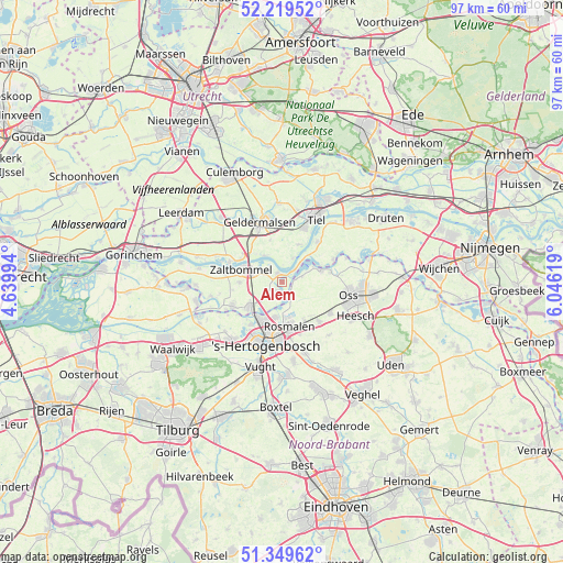
Alem GPS coordinates[2]
51° 47' 12.012" North, 5° 20' 35.016" East
| Map corner | latitude | longitude |
|---|---|---|
| Upper-left | 52.21952°, | 4.63994° |
| Center: | 51.78667°, | 5.34306° |
| Lower-right: | 51.34962°, | 6.04619° |
| Map W x H: | 96.7×96.7 km | = 60.1×60.1mi |
| max Lat: | 53.48025° ⇑65.4% North |
| Alem: | 51.78667° |
| min Lat: | ⇓34.6% South 50.76917° |
| min Long | Alem | max Long |
| 3.38611° | 5.34306° | 7.16528° |
| W 37.6%⇐ | ⇒62.4% E |
Elevation
Elevation of Alem is 6 m = 20 ft, and this is 9 m = 30 ft below average elevation for this country.
| Max E: |
203 m = 666 ft | 50.6% |
| Avg. | 15 m = 49 ft | |
| Alem | 6 m = 20 ft | |
Min E: |
-6 m = -20 ft | 49.4% |
See also: Netherlands elevation on elevation.city.
Geographical zone
Alem is located in North temperate zone (between Tropic of Cancer and the Arctic Circle). Distance of this North polar circle is 1643 km =1020.9 mi to North.| Distance of | km | miles | from Alem |
|---|---|---|---|
| North Pole | 4248.9 | 2640.1 | to North |
| Arctic Circle | 1643 | 1020.9 | to North |
| Tropic Cancer | 3152.2 | 1958.7 | to South |
| Equator | 5758.1 | 3577.9 | to South |


Nearby cities:
15 places around Alem: (largest is in red/bold)
• Bruchem
7.4 km =4.6 mi,  270°
270°
• Hedel
7.1 km =4.4 mi,  232°
232°
• Heerewaarden
4.9 km =3 mi,  44°
44°
• Hurwenen
3.2 km =2 mi,  325°
325°
• Kerkdriel
1.8 km =1.1 mi,  198°
198°
• Kruisstraat
7.1 km =4.4 mi,  149°
149°
• Lith
6.9 km =4.3 mi,  72°
72°
• Maren-Kessel
3.6 km =2.2 mi, 73°
• Ophemert
7.2 km =4.5 mi,  25°
25°
• Opijnen
5.6 km =3.5 mi, 327°
• Rossum
1.7 km =1.1 mi,  336°
336°
• Varik
4.5 km =2.8 mi, 25°
• Velddriel
3.4 km =2.1 mi, 234°
• Waardenburg
7.8 km =4.8 mi,  310°
310°
• Zaltbommel
7.3 km =4.5 mi,  290°
290°
Sources, notices
• [Note1] Compared only with cities in Netherlands existing in our database
• [Src1] Map data: © OpenStreetMap contributors (CC-BY-SA)
• [Src2] Other city data from geonames.org with taken over terms of usage.
• [Src3] Geographical zone / Annual Mean Temperature by Robert A. Rohde @ Wikipedia
