Oosterwolde geodata
Oosterwolde (Friesland) is a populated place; located in Netherlands in Europe/Amsterdam (GMT+2) time zone. With population of 9,245 people, there are 309 cities with bigger population in this country. Compared to other cities in Netherlands, 85.3% of cities are located further ↓South; 85.4% of cities are located further ←West and 55.1% of cities have lower elevation than Oosterwolde. Note1


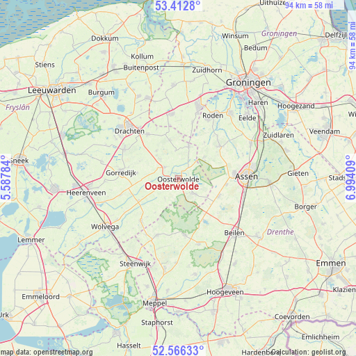
Oosterwolde GPS coordinates[2]
52° 59' 29.904" North, 6° 17' 27.456" East
| Map corner | latitude | longitude |
|---|---|---|
| Upper-left | 53.4128°, | 5.58784° |
| Center: | 52.99164°, | 6.29096° |
| Lower-right: | 52.56633°, | 6.99409° |
| Map W x H: | 94.1×94.1 km | = 58.5×58.5mi |
| max Lat: | 53.48025° ⇑14.7% North |
| Oosterwolde: | 52.99164° |
| min Lat: | ⇓85.3% South 50.76917° |
| min Long | Oosterwolde | max Long |
| 3.38611° | 6.29096° | 7.16528° |
| W 85.4%⇐ | ⇒14.6% E |
Elevation
Elevation of Oosterwolde is 8 m = 26 ft, and this is 7 m = 23 ft below average elevation for this country.
| Max E: |
203 m = 666 ft | 44.9% |
| Avg. | 15 m = 49 ft | |
| Oosterwolde | 8 m = 26 ft | |
Min E: |
-6 m = -20 ft | 55.1% |
See also: Netherlands elevation on elevation.city.
Geographical zone
Oosterwolde is located in North temperate zone (between Tropic of Cancer and the Arctic Circle). Distance of this North polar circle is 1509.1 km =937.7 mi to North.| Distance of | km | miles | from Oosterwolde |
|---|---|---|---|
| North Pole | 4114.9 | 2556.9 | to North |
| Arctic Circle | 1509.1 | 937.7 | to North |
| Tropic Cancer | 3286.2 | 2041.9 | to South |
| Equator | 5892.1 | 3661.2 | to South |


Nearby cities:
15 places around Oosterwolde: (largest is in red/bold)
• Appelscha
5.7 km =3.5 mi,  135°
135°
• Bakkeveen
10.2 km =6.3 mi,  346°
346°
• Boijl
11 km =6.8 mi,  213°
213°
• Donkerbroek
4.5 km =2.8 mi,  309°
309°
• Een
11.8 km =7.3 mi,  36°
36°
• Haulerwijk
8.6 km =5.3 mi,  19°
19°
• Hoornsterzwaag
8 km =5 mi,  275°
275°
• Jubbega
11.4 km =7.1 mi, 276°
• Lippenhuizen
13.5 km =8.4 mi, 282°
• Makkinga
5.1 km =3.2 mi,  256°
256°
• Oldeberkoop
12.3 km =7.6 mi,  240°
240°
• Siegerswoude
12.4 km =7.7 mi, 345°
• Veenhuizen
8.3 km =5.2 mi,  57°
57°
• Waskemeer
7.3 km =4.5 mi, 354°
• Wijnjewoude
9.4 km =5.8 mi,  322°
322°
Sources, notices
• [Note1] Compared only with cities in Netherlands existing in our database
• [Src1] Map data: © OpenStreetMap contributors (CC-BY-SA)
• [Src2] Other city data from geonames.org with taken over terms of usage.
• [Src3] Geographical zone / Annual Mean Temperature by Robert A. Rohde @ Wikipedia
