Veenhuizen geodata
Veenhuizen (Drenthe) is a populated place; located in Netherlands in Europe/Amsterdam (GMT+2) time zone. With population of 950 people, there are 1434 cities with bigger population in this country. Compared to other cities in Netherlands, 86.6% of cities are located further ↓South; 87.2% of cities are located further ←West and 64.6% of cities have lower elevation than Veenhuizen. Note1


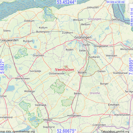
Veenhuizen GPS coordinates[2]
53° 1' 54.012" North, 6° 23' 44.988" East
| Map corner | latitude | longitude |
|---|---|---|
| Upper-left | 53.45244°, | 5.6927° |
| Center: | 53.03167°, | 6.39583° |
| Lower-right: | 52.60675°, | 7.09895° |
| Map W x H: | 94×94 km | = 58.4×58.4mi |
| max Lat: | 53.48025° ⇑13.4% North |
| Veenhuizen: | 53.03167° |
| min Lat: | ⇓86.6% South 50.76917° |
| min Long | Veenhuizen | max Long |
| 3.38611° | 6.39583° | 7.16528° |
| W 87.2%⇐ | ⇒12.8% E |
Elevation
Elevation of Veenhuizen is 12 m = 39 ft, and this is 3 m = 10 ft below average elevation for this country.
| Max E: |
203 m = 666 ft | 35.4% |
| Avg. | 15 m = 49 ft | |
| Veenhuizen | 12 m = 39 ft | |
Min E: |
-6 m = -20 ft | 64.6% |
See also: Netherlands elevation on elevation.city.
Geographical zone
Veenhuizen is located in North temperate zone (between Tropic of Cancer and the Arctic Circle). Distance of this North polar circle is 1504.6 km =934.9 mi to North.| Distance of | km | miles | from Veenhuizen |
|---|---|---|---|
| North Pole | 4110.5 | 2554.1 | to North |
| Arctic Circle | 1504.6 | 934.9 | to North |
| Tropic Cancer | 3290.6 | 2044.7 | to South |
| Equator | 5896.6 | 3664 | to South |


Nearby cities:
15 places around Veenhuizen: (largest is in red/bold)
• Appelscha
9 km =5.6 mi,  199°
199°
• Assen
11.8 km =7.3 mi,  109°
109°
• Bakkeveen
10.8 km =6.7 mi,  300°
300°
• Donkerbroek
10.6 km =6.6 mi,  261°
261°
• Een
5 km =3.1 mi,  0°
0°
• Haulerwijk
5.5 km =3.4 mi,  311°
311°
• Marsdijk
12.8 km =8 mi,  97°
97°
• Nieuw-Roden
11.1 km =6.9 mi, 0°
• Norg
5.7 km =3.5 mi,  47°
47°
• Oosterwolde
8.3 km =5.2 mi,  237°
237°
• Peelo
11.2 km =7 mi, 98°
• Roden
11.9 km =7.4 mi,  8°
8°
• Siegerswoude
12.6 km =7.8 mi, 306°
• Waskemeer
8.2 km =5.1 mi,  289°
289°
• Zeyen
10.2 km =6.3 mi,  80°
80°
Sources, notices
• [Note1] Compared only with cities in Netherlands existing in our database
• [Src1] Map data: © OpenStreetMap contributors (CC-BY-SA)
• [Src2] Other city data from geonames.org with taken over terms of usage.
• [Src3] Geographical zone / Annual Mean Temperature by Robert A. Rohde @ Wikipedia
