Appelscha geodata
Appelscha (Friesland) is a populated place; located in Netherlands in Europe/Amsterdam (GMT+2) time zone. With population of 4,035 people, there are 582 cities with bigger population in this country. Compared to other cities in Netherlands, 84.2% of cities are located further ↓South; 86.4% of cities are located further ←West and 57.3% of cities have lower elevation than Appelscha. Note1


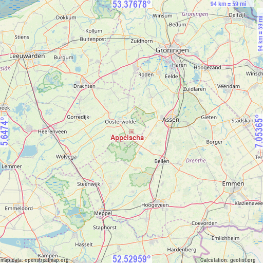
Appelscha GPS coordinates[2]
52° 57' 18.936" North, 6° 21' 1.908" East
| Map corner | latitude | longitude |
|---|---|---|
| Upper-left | 53.37678°, | 5.6474° |
| Center: | 52.95526°, | 6.35053° |
| Lower-right: | 52.52959°, | 7.05365° |
| Map W x H: | 94.2×94.2 km | = 58.5×58.5mi |
| max Lat: | 53.48025° ⇑15.8% North |
| Appelscha: | 52.95526° |
| min Lat: | ⇓84.2% South 50.76917° |
| min Long | Appelscha | max Long |
| 3.38611° | 6.35053° | 7.16528° |
| W 86.4%⇐ | ⇒13.6% E |
Elevation
Elevation of Appelscha is 9 m = 30 ft, and this is 6 m = 20 ft below average elevation for this country.
| Max E: |
203 m = 666 ft | 42.7% |
| Avg. | 15 m = 49 ft | |
| Appelscha | 9 m = 30 ft | |
Min E: |
-6 m = -20 ft | 57.3% |
See also: Netherlands elevation on elevation.city.
Geographical zone
Appelscha is located in North temperate zone (between Tropic of Cancer and the Arctic Circle). Distance of this North polar circle is 1513.1 km =940.2 mi to North.| Distance of | km | miles | from Appelscha |
|---|---|---|---|
| North Pole | 4119 | 2559.4 | to North |
| Arctic Circle | 1513.1 | 940.2 | to North |
| Tropic Cancer | 3282.2 | 2039.5 | to South |
| Equator | 5888.1 | 3658.7 | to South |


Nearby cities:
15 places around Appelscha: (largest is in red/bold)
• Boijl
11.3 km =7 mi,  243°
243°
• Diever
11.4 km =7.1 mi,  190°
190°
• Donkerbroek
10.2 km =6.3 mi,  312°
312°
• Dwingeloo
13.5 km =8.4 mi,  174°
174°
• Een
13.8 km =8.6 mi,  12°
12°
• Haulerwijk
12.2 km =7.6 mi,  354°
354°
• Hijken
11.9 km =7.4 mi,  124°
124°
• Hooghalen
13.2 km =8.2 mi,  106°
106°
• Hoornsterzwaag
12.8 km =8 mi,  292°
292°
• Makkinga
9.4 km =5.8 mi, 287°
• Norg
14.3 km =8.9 mi,  30°
30°
• Oosterstreek
14.2 km =8.8 mi, 243°
• Oosterwolde
5.7 km =3.5 mi,  315°
315°
• Veenhuizen
9 km =5.6 mi,  19°
19°
• Waskemeer
12.2 km =7.6 mi,  337°
337°
Sources, notices
• [Note1] Compared only with cities in Netherlands existing in our database
• [Src1] Map data: © OpenStreetMap contributors (CC-BY-SA)
• [Src2] Other city data from geonames.org with taken over terms of usage.
• [Src3] Geographical zone / Annual Mean Temperature by Robert A. Rohde @ Wikipedia
