Oentsjerk geodata
Oentsjerk (Friesland) is a populated place; located in Netherlands in Europe/Amsterdam (GMT+2) time zone. With population of 1,790 people, there are 1020 cities with bigger population in this country. Compared to other cities in Netherlands, 95.7% of cities are located further ↓South; 64.5% of cities are located further ←West and 91.3% of cities have higher elevation than Oentsjerk. Note1


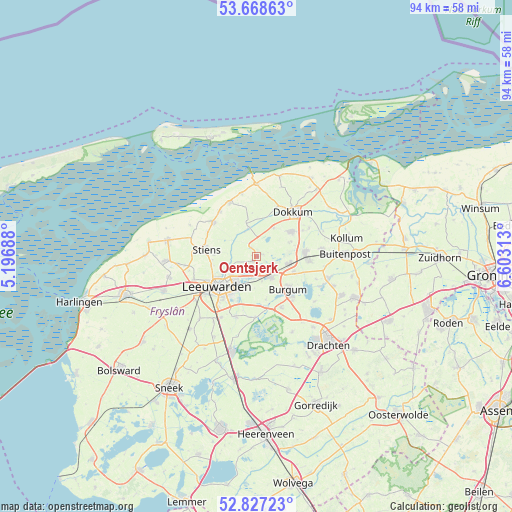
Oentsjerk GPS coordinates[2]
53° 15' 0" North, 5° 54' 0" East
| Map corner | latitude | longitude |
|---|---|---|
| Upper-left | 53.66863°, | 5.19688° |
| Center: | 53.25°, | 5.9° |
| Lower-right: | 52.82723°, | 6.60313° |
| Map W x H: | 93.6×93.6 km | = 58.2×58.2mi |
| max Lat: | 53.48025° ⇑4.3% North |
| Oentsjerk: | 53.25° |
| min Lat: | ⇓95.7% South 50.76917° |
| min Long | Oentsjerk | max Long |
| 3.38611° | 5.9° | 7.16528° |
| W 64.5%⇐ | ⇒35.5% E |
Elevation
Elevation of Oentsjerk is 0 m = 0 ft, and this is 15 m = 49 ft below average elevation for this country.
| Max E: |
203 m = 666 ft | 91.3% |
| Avg. | 15 m = 49 ft | |
| Oentsjerk | 0 m = 0 ft | |
Min E: |
-6 m = -20 ft | 8.7% |
See also: Netherlands elevation on elevation.city.
Geographical zone
Oentsjerk is located in North temperate zone (between Tropic of Cancer and the Arctic Circle). Distance of this North polar circle is 1480.3 km =919.8 mi to North.| Distance of | km | miles | from Oentsjerk |
|---|---|---|---|
| North Pole | 4086.2 | 2539 | to North |
| Arctic Circle | 1480.3 | 919.8 | to North |
| Tropic Cancer | 3314.9 | 2059.8 | to South |
| Equator | 5920.8 | 3679 | to South |


Nearby cities:
15 places around Oentsjerk: (largest is in red/bold)
• Aldtsjerk
2 km =1.2 mi,  334°
334°
• Britsum
7.6 km =4.7 mi,  273°
273°
• Broeksterwâld
7 km =4.3 mi,  66°
66°
• Burdaard
5.1 km =3.2 mi,  344°
344°
• Camminghaburen
5.9 km =3.7 mi,  220°
220°
• Damwâld
7.9 km =4.9 mi,  55°
55°
• Feanwâlden
6.1 km =3.8 mi,  105°
105°
• Gytsjerk
0.9 km =0.6 mi,  202°
202°
• Heechterp
6.8 km =4.2 mi,  228°
228°
• Hurdegaryp
4.9 km =3 mi,  145°
145°
• Mûnein
1.4 km =0.9 mi,  77°
77°
• Noardburgum
7.7 km =4.8 mi, 114°
• Rinsumageast
6.2 km =3.9 mi,  32°
32°
• Ryptsjerk
3.3 km =2.1 mi,  159°
159°
• Tytsjerk
4.1 km =2.5 mi,  171°
171°
Sources, notices
• [Note1] Compared only with cities in Netherlands existing in our database
• [Src1] Map data: © OpenStreetMap contributors (CC-BY-SA)
• [Src2] Other city data from geonames.org with taken over terms of usage.
• [Src3] Geographical zone / Annual Mean Temperature by Robert A. Rohde @ Wikipedia
