Broeksterwâld geodata
Broeksterwâld (Friesland) is a populated place; located in Netherlands in Europe/Amsterdam (GMT+2) time zone. With population of 1,115 people, there are 1323 cities with bigger population in this country. Compared to other cities in Netherlands, 96.7% of cities are located further ↓South; 72.5% of cities are located further ←West and 91.3% of cities have higher elevation than Broeksterwâld. Note1


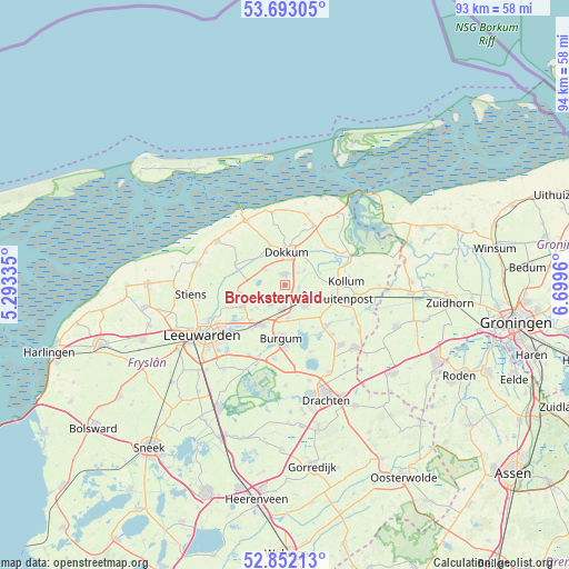
Broeksterwâld GPS coordinates[2]
53° 16' 28.776" North, 5° 59' 47.328" East
| Map corner | latitude | longitude |
|---|---|---|
| Upper-left | 53.69305°, | 5.29335° |
| Center: | 53.27466°, | 5.99648° |
| Lower-right: | 52.85213°, | 6.6996° |
| Map W x H: | 93.5×93.5 km | = 58.1×58.1mi |
| max Lat: | 53.48025° ⇑3.3% North |
| Broeksterwâld: | 53.27466° |
| min Lat: | ⇓96.7% South 50.76917° |
| min Long | Broeksterwâld | max Long |
| 3.38611° | 5.99648° | 7.16528° |
| W 72.5%⇐ | ⇒27.5% E |
Elevation
Elevation of Broeksterwâld is 0 m = 0 ft, and this is 15 m = 49 ft below average elevation for this country.
| Max E: |
203 m = 666 ft | 91.3% |
| Avg. | 15 m = 49 ft | |
| Broeksterwâld | 0 m = 0 ft | |
Min E: |
-6 m = -20 ft | 8.7% |
See also: Netherlands elevation on elevation.city.
Geographical zone
Broeksterwâld is located in North temperate zone (between Tropic of Cancer and the Arctic Circle). Distance of this North polar circle is 1477.6 km =918.1 mi to North.| Distance of | km | miles | from Broeksterwâld |
|---|---|---|---|
| North Pole | 4083.5 | 2537.4 | to North |
| Arctic Circle | 1477.6 | 918.1 | to North |
| Tropic Cancer | 3317.7 | 2061.5 | to South |
| Equator | 5923.6 | 3680.8 | to South |


Nearby cities:
15 places around Broeksterwâld: (largest is in red/bold)
• Aldtsjerk
7.3 km =4.5 mi,  262°
262°
• Damwâld
1.8 km =1.1 mi,  2°
2°
• De Westereen
3.3 km =2.1 mi,  126°
126°
• Dokkum
5.3 km =3.3 mi, 0°
• Driezum
4.1 km =2.5 mi,  54°
54°
• Feanwâlden
4.4 km =2.7 mi,  187°
187°
• Gytsjerk
7.6 km =4.7 mi,  242°
242°
• Kollumerzwaag
5.4 km =3.4 mi,  104°
104°
• Mûnein
5.6 km =3.5 mi, 244°
• Noardburgum
6 km =3.7 mi,  174°
174°
• Oentsjerk
7 km =4.3 mi,  246°
246°
• Rinsumageast
4 km =2.5 mi,  308°
308°
• Twijzelerheide
5.1 km =3.2 mi,  139°
139°
• Wâlterswâld
3.7 km =2.3 mi,  41°
41°
• Zwagerbosch
4.5 km =2.8 mi, 130°
Sources, notices
• [Note1] Compared only with cities in Netherlands existing in our database
• [Src1] Map data: © OpenStreetMap contributors (CC-BY-SA)
• [Src2] Other city data from geonames.org with taken over terms of usage.
• [Src3] Geographical zone / Annual Mean Temperature by Robert A. Rohde @ Wikipedia
