Numansdorp geodata
Numansdorp (South Holland) is a populated place; located in Netherlands in Europe/Amsterdam (GMT+2) time zone. With population of 4,280 people, there are 559 cities with bigger population in this country. Compared to other cities in Netherlands, 67.7% of cities are located further ↑North; 91.2% of cities are located further →East and 83.9% of cities have higher elevation than Numansdorp. Note1


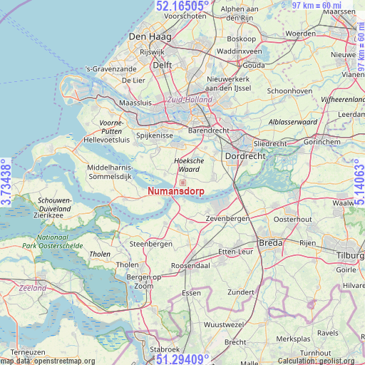
Numansdorp GPS coordinates[2]
51° 43' 54.012" North, 4° 26' 15" East
| Map corner | latitude | longitude |
|---|---|---|
| Upper-left | 52.16505°, | 3.73438° |
| Center: | 51.73167°, | 4.4375° |
| Lower-right: | 51.29409°, | 5.14063° |
| Map W x H: | 96.8×96.8 km | = 60.1×60.1mi |
| max Lat: | 53.48025° ⇑67.7% North |
| Numansdorp: | 51.73167° |
| min Lat: | ⇓32.3% South 50.76917° |
| min Long | Numansdorp | max Long |
| 3.38611° | 4.4375° | 7.16528° |
| W 8.8%⇐ | ⇒91.2% E |
Elevation
Elevation of Numansdorp is 1 m = 3 ft, and this is 14 m = 46 ft below average elevation for this country.
| Max E: |
203 m = 666 ft | 83.9% |
| Avg. | 15 m = 49 ft | |
| Numansdorp | 1 m = 3 ft | |
Min E: |
-6 m = -20 ft | 16.1% |
See also: Netherlands elevation on elevation.city.
Geographical zone
Numansdorp is located in North temperate zone (between Tropic of Cancer and the Arctic Circle). Distance of this North polar circle is 1649.2 km =1024.8 mi to North.| Distance of | km | miles | from Numansdorp |
|---|---|---|---|
| North Pole | 4255 | 2643.9 | to North |
| Arctic Circle | 1649.2 | 1024.8 | to North |
| Tropic Cancer | 3146.1 | 1954.9 | to South |
| Equator | 5752 | 3574.1 | to South |


Nearby cities:
15 places around Numansdorp: (largest is in red/bold)
• Fijnaart
10.7 km =6.6 mi,  168°
168°
• Heijningen
8.7 km =5.4 mi,  193°
193°
• Heinenoord
10.8 km =6.7 mi,  14°
14°
• Helwijk
6.2 km =3.9 mi,  183°
183°
• Klaaswaal
4.3 km =2.7 mi, 7°
• Klundert
10 km =6.2 mi,  137°
137°
• Maasdam
10.3 km =6.4 mi,  51°
51°
• Middelsluis
1.2 km =0.7 mi, 13°
• Mijnsheerenland
8 km =5 mi,  25°
25°
• Oud-Beijerland
10.4 km =6.5 mi,  350°
350°
• Piershil
10.9 km =6.8 mi,  308°
308°
• Strijen
7.9 km =4.9 mi,  79°
79°
• Westmaas
6.6 km =4.1 mi,  22°
22°
• Willemstad
4.4 km =2.7 mi, 178°
• Zuid-Beijerland
5.2 km =3.2 mi,  294°
294°
Sources, notices
• [Note1] Compared only with cities in Netherlands existing in our database
• [Src1] Map data: © OpenStreetMap contributors (CC-BY-SA)
• [Src2] Other city data from geonames.org with taken over terms of usage.
• [Src3] Geographical zone / Annual Mean Temperature by Robert A. Rohde @ Wikipedia
