Willemstad geodata
Willemstad (North Brabant) is a populated place; located in Netherlands in Europe/Amsterdam (GMT+2) time zone. With population of 800 people, there are 1531 cities with bigger population in this country. Compared to other cities in Netherlands, 69.2% of cities are located further ↑North; 91.2% of cities are located further →East and 83.9% of cities have higher elevation than Willemstad. Note1


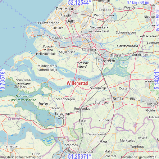
Willemstad GPS coordinates[2]
51° 41' 30.012" North, 4° 26' 20.004" East
| Map corner | latitude | longitude |
|---|---|---|
| Upper-left | 52.12544°, | 3.73576° |
| Center: | 51.69167°, | 4.43889° |
| Lower-right: | 51.25371°, | 5.14201° |
| Map W x H: | 96.9×96.9 km | = 60.2×60.2mi |
| max Lat: | 53.48025° ⇑69.2% North |
| Willemstad: | 51.69167° |
| min Lat: | ⇓30.8% South 50.76917° |
| min Long | Willemstad | max Long |
| 3.38611° | 4.43889° | 7.16528° |
| W 8.8%⇐ | ⇒91.2% E |
Elevation
Elevation of Willemstad is 1 m = 3 ft, and this is 14 m = 46 ft below average elevation for this country.
| Max E: |
203 m = 666 ft | 83.9% |
| Avg. | 15 m = 49 ft | |
| Willemstad | 1 m = 3 ft | |
Min E: |
-6 m = -20 ft | 16.1% |
See also: Netherlands elevation on elevation.city.
Geographical zone
Willemstad is located in North temperate zone (between Tropic of Cancer and the Arctic Circle). Distance of this North polar circle is 1653.6 km =1027.5 mi to North.| Distance of | km | miles | from Willemstad |
|---|---|---|---|
| North Pole | 4259.5 | 2646.7 | to North |
| Arctic Circle | 1653.6 | 1027.5 | to North |
| Tropic Cancer | 3141.7 | 1952.2 | to South |
| Equator | 5747.6 | 3571.4 | to South |


Nearby cities:
15 places around Willemstad: (largest is in red/bold)
• Dinteloord
7.9 km =4.9 mi,  217°
217°
• Fijnaart
6.4 km =4 mi,  160°
160°
• Heijningen
4.5 km =2.8 mi,  207°
207°
• Helwijk
1.8 km =1.1 mi,  195°
195°
• Klaaswaal
8.7 km =5.4 mi,  3°
3°
• Klundert
7.2 km =4.5 mi,  114°
114°
• Middelsluis
5.7 km =3.5 mi, 1°
• Noordhoek
8.4 km =5.2 mi,  130°
130°
• Numansdorp
4.4 km =2.7 mi,  358°
358°
• Stampersgat
8.7 km =5.4 mi,  177°
177°
• Standdaarbuiten
10.1 km =6.3 mi,  149°
149°
• Stoof
10.6 km =6.6 mi,  165°
165°
• Strijen
9.7 km =6 mi,  52°
52°
• Westmaas
10.9 km =6.8 mi,  13°
13°
• Zuid-Beijerland
8.2 km =5.1 mi,  323°
323°
Sources, notices
• [Note1] Compared only with cities in Netherlands existing in our database
• [Src1] Map data: © OpenStreetMap contributors (CC-BY-SA)
• [Src2] Other city data from geonames.org with taken over terms of usage.
• [Src3] Geographical zone / Annual Mean Temperature by Robert A. Rohde @ Wikipedia
