Noorbeek geodata
Noorbeek (Limburg) is a populated place; located in Netherlands in Europe/Amsterdam (GMT+2) time zone. With population of 750 people, there are 1566 cities with bigger population in this country. Compared to other cities in Netherlands, 100% of cities are located further ↑North; 58.5% of cities are located further ←West and 98.9% of cities have lower elevation than Noorbeek. Note1


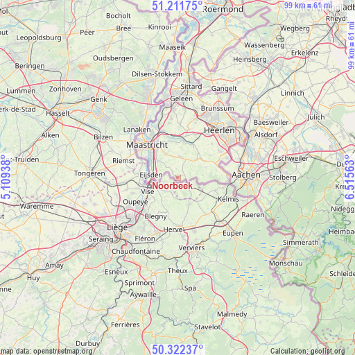
Noorbeek GPS coordinates[2]
50° 46' 9.012" North, 5° 48' 45" East
| Map corner | latitude | longitude |
|---|---|---|
| Upper-left | 51.21175°, | 5.10938° |
| Center: | 50.76917°, | 5.8125° |
| Lower-right: | 50.32237°, | 6.51563° |
| Map W x H: | 98.9×98.9 km | = 61.5×61.5mi |
| max Lat: | 53.48025° ⇑100% North |
| Noorbeek: | 50.76917° |
| min Lat: | ⇓0% South 50.76917° |
| min Long | Noorbeek | max Long |
| 3.38611° | 5.8125° | 7.16528° |
| W 58.5%⇐ | ⇒41.5% E |
Elevation
Elevation of Noorbeek is 148 m = 486 ft, and this is 133 m = 436 ft above average elevation for this country.
| Max E: |
203 m = 666 ft | 1.1% |
| Noorbeek | 148 m 486 ft | |
| Avg. | 15 m = 49 ft | |
Min E: |
-6 m = -20 ft | 98.9% |
See also: Netherlands elevation on elevation.city.
Geographical zone
Noorbeek is located in North temperate zone (between Tropic of Cancer and the Arctic Circle). Distance of this North polar circle is 1756.2 km =1091.3 mi to North.| Distance of | km | miles | from Noorbeek |
|---|---|---|---|
| North Pole | 4362.1 | 2710.5 | to North |
| Arctic Circle | 1756.2 | 1091.3 | to North |
| Tropic Cancer | 3039.1 | 1888.4 | to South |
| Equator | 5645 | 3507.6 | to South |


Nearby cities:
15 places around Noorbeek: (largest is in red/bold)
• Banholt
2.3 km =1.4 mi,  352°
352°
• De Heeg
8.8 km =5.5 mi,  314°
314°
• Eckelrade
5.4 km =3.4 mi,  322°
322°
• Eijsden
6.8 km =4.2 mi,  280°
280°
• Epen
7 km =4.3 mi,  83°
83°
• Gronsveld
7.4 km =4.6 mi, 308°
• Gulpen
7.5 km =4.7 mi,  45°
45°
• Margraten
5.8 km =3.6 mi,  5°
5°
• Mechelen
8.5 km =5.3 mi,  69°
69°
• Mheer
1.9 km =1.2 mi, 309°
• Oost
7.8 km =4.8 mi,  292°
292°
• Reijmerstok
3.8 km =2.4 mi,  27°
27°
• Rijckholt
6.6 km =4.1 mi,  300°
300°
• Sibbe
8.4 km =5.2 mi, 6°
• Sint Geertruid
4.5 km =2.8 mi, 312°
Sources, notices
• [Note1] Compared only with cities in Netherlands existing in our database
• [Src1] Map data: © OpenStreetMap contributors (CC-BY-SA)
• [Src2] Other city data from geonames.org with taken over terms of usage.
• [Src3] Geographical zone / Annual Mean Temperature by Robert A. Rohde @ Wikipedia
