Mechelen geodata
Mechelen (Limburg) is a populated place; located in Netherlands in Europe/Amsterdam (GMT+2) time zone. With population of 1,375 people, there are 1194 cities with bigger population in this country. Compared to other cities in Netherlands, 99.5% of cities are located further ↑North; 65.9% of cities are located further ←West and 97.6% of cities have lower elevation than Mechelen. Note1


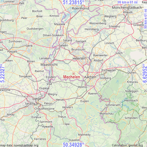
Mechelen GPS coordinates[2]
50° 47' 44.988" North, 5° 55' 35.004" East
| Map corner | latitude | longitude |
|---|---|---|
| Upper-left | 51.23815°, | 5.22327° |
| Center: | 50.79583°, | 5.92639° |
| Lower-right: | 50.34928°, | 6.62952° |
| Map W x H: | 98.8×98.8 km | = 61.4×61.4mi |
| max Lat: | 53.48025° ⇑99.5% North |
| Mechelen: | 50.79583° |
| min Lat: | ⇓0.5% South 50.76917° |
| min Long | Mechelen | max Long |
| 3.38611° | 5.92639° | 7.16528° |
| W 65.9%⇐ | ⇒34.1% E |
Elevation
Elevation of Mechelen is 110 m = 361 ft, and this is 95 m = 312 ft above average elevation for this country.
| Max E: |
203 m = 666 ft | 2.4% |
| Mechelen | 110 m 361 ft | |
| Avg. | 15 m = 49 ft | |
Min E: |
-6 m = -20 ft | 97.6% |
See also: Netherlands elevation on elevation.city.
Geographical zone
Mechelen is located in North temperate zone (between Tropic of Cancer and the Arctic Circle). Distance of this North polar circle is 1753.2 km =1089.4 mi to North.| Distance of | km | miles | from Mechelen |
|---|---|---|---|
| North Pole | 4359.1 | 2708.6 | to North |
| Arctic Circle | 1753.2 | 1089.4 | to North |
| Tropic Cancer | 3042 | 1890.2 | to South |
| Equator | 5648 | 3509.5 | to South |


Nearby cities:
15 places around Mechelen: (largest is in red/bold)
• Bocholtz
6.1 km =3.8 mi,  65°
65°
• Bocholtzerheide
5 km =3.1 mi,  63°
63°
• Epen
2.5 km =1.6 mi,  205°
205°
• Gulpen
3.4 km =2.1 mi,  310°
310°
• Lemiers
4.8 km =3 mi,  103°
103°
• Margraten
7.9 km =4.9 mi,  290°
290°
• Nijswiller
2.6 km =1.6 mi, 55°
• Ransdaal
8.1 km =5 mi,  342°
342°
• Reijmerstok
6.3 km =3.9 mi,  273°
273°
• Schin op Geul
7.6 km =4.7 mi,  328°
328°
• Simpelveld
5.8 km =3.6 mi,  42°
42°
• Ubachsberg
6.6 km =4.1 mi,  13°
13°
• Vaals
7 km =4.3 mi,  113°
113°
• Vijlen
2.9 km =1.8 mi, 106°
• Wijlre
4.7 km =2.9 mi, 332°
Sources, notices
• [Note1] Compared only with cities in Netherlands existing in our database
• [Src1] Map data: © OpenStreetMap contributors (CC-BY-SA)
• [Src2] Other city data from geonames.org with taken over terms of usage.
• [Src3] Geographical zone / Annual Mean Temperature by Robert A. Rohde @ Wikipedia
