Nieuw-Roden geodata
Nieuw-Roden (Drenthe) is a populated place; located in Netherlands in Europe/Amsterdam (GMT+2) time zone. With population of 1,300 people, there are 1238 cities with bigger population in this country. Compared to other cities in Netherlands, 89.8% of cities are located further ↓South; 87.4% of cities are located further ←West and 54.1% of cities have higher elevation than Nieuw-Roden. Note1


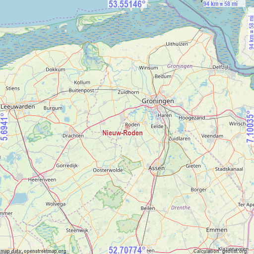
Nieuw-Roden GPS coordinates[2]
53° 7' 54.012" North, 6° 23' 49.992" East
| Map corner | latitude | longitude |
|---|---|---|
| Upper-left | 53.55146°, | 5.6941° |
| Center: | 53.13167°, | 6.39722° |
| Lower-right: | 52.70774°, | 7.10035° |
| Map W x H: | 93.8×93.8 km | = 58.3×58.3mi |
| max Lat: | 53.48025° ⇑10.2% North |
| Nieuw-Roden: | 53.13167° |
| min Lat: | ⇓89.8% South 50.76917° |
| min Long | Nieuw-Roden | max Long |
| 3.38611° | 6.39722° | 7.16528° |
| W 87.4%⇐ | ⇒12.6% E |
Elevation
Elevation of Nieuw-Roden is 5 m = 16 ft, and this is 10 m = 33 ft below average elevation for this country.
| Max E: |
203 m = 666 ft | 54.1% |
| Avg. | 15 m = 49 ft | |
| Nieuw-Roden | 5 m = 16 ft | |
Min E: |
-6 m = -20 ft | 45.9% |
See also: Netherlands elevation on elevation.city.
Geographical zone
Nieuw-Roden is located in North temperate zone (between Tropic of Cancer and the Arctic Circle). Distance of this North polar circle is 1493.5 km =928 mi to North.| Distance of | km | miles | from Nieuw-Roden |
|---|---|---|---|
| North Pole | 4099.4 | 2547.2 | to North |
| Arctic Circle | 1493.5 | 928 | to North |
| Tropic Cancer | 3301.8 | 2051.6 | to South |
| Equator | 5907.7 | 3670.9 | to South |


Nearby cities:
15 places around Nieuw-Roden: (largest is in red/bold)
• Diepswal
2.8 km =1.7 mi,  317°
317°
• Eelde
11 km =6.8 mi,  87°
87°
• Een
6.1 km =3.8 mi,  180°
180°
• Haulerwijk
8.5 km =5.3 mi,  209°
209°
• Leek
3.7 km =2.3 mi,  337°
337°
• Marum
9.1 km =5.7 mi,  278°
278°
• Niebert
5.7 km =3.5 mi,  304°
304°
• Niekerk
10.8 km =6.7 mi, 344°
• Nietap
3.1 km =1.9 mi,  3°
3°
• Norg
8.3 km =5.2 mi,  150°
150°
• Nuis
6.5 km =4 mi,  289°
289°
• Oldekerk
10.4 km =6.5 mi, 338°
• Peize
6.9 km =4.3 mi,  75°
75°
• Roden
1.7 km =1.1 mi,  67°
67°
• Siegerswoude
10.8 km =6.7 mi,  250°
250°
Sources, notices
• [Note1] Compared only with cities in Netherlands existing in our database
• [Src1] Map data: © OpenStreetMap contributors (CC-BY-SA)
• [Src2] Other city data from geonames.org with taken over terms of usage.
• [Src3] Geographical zone / Annual Mean Temperature by Robert A. Rohde @ Wikipedia
