Oldekerk geodata
Oldekerk (Groningen) is a populated place; located in Netherlands in Europe/Amsterdam (GMT+2) time zone. With population of 855 people, there are 1490 cities with bigger population in this country. Compared to other cities in Netherlands, 94.3% of cities are located further ↓South; 86.3% of cities are located further ←West and 83.9% of cities have higher elevation than Oldekerk. Note1


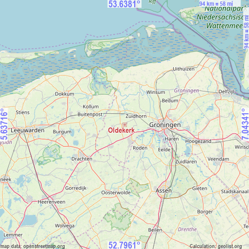
Oldekerk GPS coordinates[2]
53° 13' 9.012" North, 6° 20' 25.008" East
| Map corner | latitude | longitude |
|---|---|---|
| Upper-left | 53.6381°, | 5.63716° |
| Center: | 53.21917°, | 6.34028° |
| Lower-right: | 52.7961°, | 7.04341° |
| Map W x H: | 93.6×93.6 km | = 58.2×58.2mi |
| max Lat: | 53.48025° ⇑5.7% North |
| Oldekerk: | 53.21917° |
| min Lat: | ⇓94.3% South 50.76917° |
| min Long | Oldekerk | max Long |
| 3.38611° | 6.34028° | 7.16528° |
| W 86.3%⇐ | ⇒13.7% E |
Elevation
Elevation of Oldekerk is 1 m = 3 ft, and this is 14 m = 46 ft below average elevation for this country.
| Max E: |
203 m = 666 ft | 83.9% |
| Avg. | 15 m = 49 ft | |
| Oldekerk | 1 m = 3 ft | |
Min E: |
-6 m = -20 ft | 16.1% |
See also: Netherlands elevation on elevation.city.
Geographical zone
Oldekerk is located in North temperate zone (between Tropic of Cancer and the Arctic Circle). Distance of this North polar circle is 1483.8 km =922 mi to North.| Distance of | km | miles | from Oldekerk |
|---|---|---|---|
| North Pole | 4089.6 | 2541.2 | to North |
| Arctic Circle | 1483.8 | 922 | to North |
| Tropic Cancer | 3311.5 | 2057.7 | to South |
| Equator | 5917.4 | 3676.9 | to South |


Nearby cities:
15 places around Oldekerk: (largest is in red/bold)
• Aduard
9 km =5.6 mi,  62°
62°
• Diepswal
7.9 km =4.9 mi,  165°
165°
• Doezum
6.4 km =4 mi,  251°
251°
• Grijpskerk
5.3 km =3.3 mi,  336°
336°
• Grootegast
4.5 km =2.8 mi,  260°
260°
• Kommerzijl
7.6 km =4.7 mi,  352°
352°
• Kornhorn
7.7 km =4.8 mi,  237°
237°
• Leek
6.7 km =4.2 mi,  159°
159°
• Lutjegast
5.7 km =3.5 mi,  287°
287°
• Niebert
6.5 km =4 mi,  187°
187°
• Niekerk
1.1 km =0.7 mi,  52°
52°
• Nietap
7.8 km =4.8 mi,  149°
149°
• Noordhorn
6 km =3.7 mi,  38°
38°
• Nuis
7.9 km =4.9 mi,  196°
196°
• Zuidhorn
5.2 km =3.2 mi, 53°
Sources, notices
• [Note1] Compared only with cities in Netherlands existing in our database
• [Src1] Map data: © OpenStreetMap contributors (CC-BY-SA)
• [Src2] Other city data from geonames.org with taken over terms of usage.
• [Src3] Geographical zone / Annual Mean Temperature by Robert A. Rohde @ Wikipedia
