Nieuwdorp geodata
Nieuwdorp (Limburg) is a section of populated place; located in Netherlands in Europe/Amsterdam (GMT+2) time zone. With population of 2,445 people, there are 851 cities with bigger population in this country. Compared to other cities in Netherlands, 94.3% of cities are located further ↑North; 55.9% of cities are located further ←West and 94.6% of cities have lower elevation than Nieuwdorp. Note1


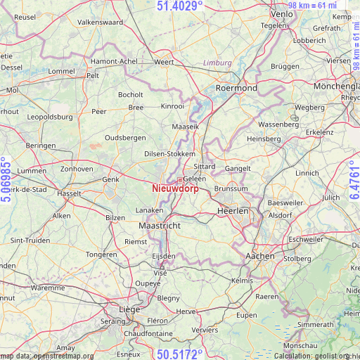
Nieuwdorp GPS coordinates[2]
50° 57' 43.776" North, 5° 46' 22.692" East
| Map corner | latitude | longitude |
|---|---|---|
| Upper-left | 51.4029°, | 5.06985° |
| Center: | 50.96216°, | 5.77297° |
| Lower-right: | 50.5172°, | 6.4761° |
| Map W x H: | 98.5×98.5 km | = 61.2×61.2mi |
| max Lat: | 53.48025° ⇑94.3% North |
| Nieuwdorp: | 50.96216° |
| min Lat: | ⇓5.7% South 50.76917° |
| min Long | Nieuwdorp | max Long |
| 3.38611° | 5.77297° | 7.16528° |
| W 55.9%⇐ | ⇒44.1% E |
Elevation
Elevation of Nieuwdorp is 62 m = 203 ft, and this is 47 m = 154 ft above average elevation for this country.
| Max E: |
203 m = 666 ft | 5.4% |
| Nieuwdorp | 62 m 203 ft | |
| Avg. | 15 m = 49 ft | |
Min E: |
-6 m = -20 ft | 94.6% |
See also: Netherlands elevation on elevation.city.
Geographical zone
Nieuwdorp is located in North temperate zone (between Tropic of Cancer and the Arctic Circle). Distance of this North polar circle is 1734.7 km =1077.9 mi to North.| Distance of | km | miles | from Nieuwdorp |
|---|---|---|---|
| North Pole | 4340.6 | 2697.1 | to North |
| Arctic Circle | 1734.7 | 1077.9 | to North |
| Tropic Cancer | 3060.5 | 1901.7 | to South |
| Equator | 5666.5 | 3521 | to South |


Nearby cities:
15 places around Nieuwdorp: (largest is in red/bold)
• Beek
2.9 km =1.8 mi,  144°
144°
• Berg
4.7 km =2.9 mi,  358°
358°
• Catsop
2.6 km =1.6 mi,  189°
189°
• Einighausen
5.8 km =3.6 mi,  41°
41°
• Elsloo
1.5 km =0.9 mi, 185°
• Geleen
4.2 km =2.6 mi,  71°
71°
• Kerensheide
1.1 km =0.7 mi,  13°
13°
• Lindenheuvel
4 km =2.5 mi,  50°
50°
• Meers
2.2 km =1.4 mi,  268°
268°
• Neerbeek
3.3 km =2.1 mi,  114°
114°
• Spaubeek
5.5 km =3.4 mi,  116°
116°
• Stein
0.9 km =0.6 mi,  330°
330°
• Sweikhuizen
5.3 km =3.3 mi,  99°
99°
• Ulestraten
6.3 km =3.9 mi,  174°
174°
• Urmond
3.2 km =2 mi, 359°
Sources, notices
• [Note1] Compared only with cities in Netherlands existing in our database
• [Src1] Map data: © OpenStreetMap contributors (CC-BY-SA)
• [Src2] Other city data from geonames.org with taken over terms of usage.
• [Src3] Geographical zone / Annual Mean Temperature by Robert A. Rohde @ Wikipedia
