Berg geodata
Berg (Limburg) is a populated place; located in Netherlands in Europe/Amsterdam (GMT+2) time zone. With population of 1,985 people, there are 966 cities with bigger population in this country. Compared to other cities in Netherlands, 93.4% of cities are located further ↑North; 55.7% of cities are located further ←West and 92.9% of cities have lower elevation than Berg. Note1


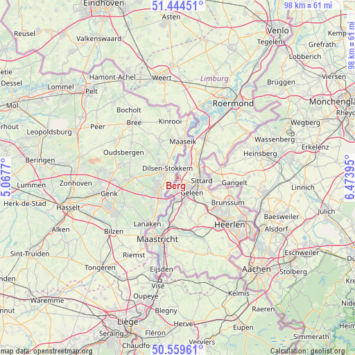
Berg GPS coordinates[2]
51° 0' 15.012" North, 5° 46' 14.988" East
| Map corner | latitude | longitude |
|---|---|---|
| Upper-left | 51.44451°, | 5.0677° |
| Center: | 51.00417°, | 5.77083° |
| Lower-right: | 50.55961°, | 6.47395° |
| Map W x H: | 98.4×98.4 km | = 61.1×61.1mi |
| max Lat: | 53.48025° ⇑93.4% North |
| Berg: | 51.00417° |
| min Lat: | ⇓6.6% South 50.76917° |
| min Long | Berg | max Long |
| 3.38611° | 5.77083° | 7.16528° |
| W 55.7%⇐ | ⇒44.3% E |
Elevation
Elevation of Berg is 47 m = 154 ft, and this is 32 m = 105 ft above average elevation for this country.
| Max E: |
203 m = 666 ft | 7.1% |
| Berg | 47 m 154 ft | |
| Avg. | 15 m = 49 ft | |
Min E: |
-6 m = -20 ft | 92.9% |
See also: Netherlands elevation on elevation.city.
Geographical zone
Berg is located in North temperate zone (between Tropic of Cancer and the Arctic Circle). Distance of this North polar circle is 1730 km =1075 mi to North.| Distance of | km | miles | from Berg |
|---|---|---|---|
| North Pole | 4335.9 | 2694.2 | to North |
| Arctic Circle | 1730 | 1075 | to North |
| Tropic Cancer | 3065.2 | 1904.6 | to South |
| Equator | 5671.1 | 3523.9 | to South |


Nearby cities:
15 places around Berg: (largest is in red/bold)
• Born
4.1 km =2.5 mi,  41°
41°
• Buchten
5.1 km =3.2 mi,  31°
31°
• Einighausen
4 km =2.5 mi,  93°
93°
• Geleen
5.3 km =3.3 mi,  129°
129°
• Grevenbicht
3.8 km =2.4 mi,  4°
4°
• Guttecoven
3.5 km =2.2 mi,  69°
69°
• Kerensheide
3.6 km =2.2 mi,  173°
173°
• Limbricht
4.7 km =2.9 mi,  79°
79°
• Lindenheuvel
3.8 km =2.4 mi,  123°
123°
• Meers
5.1 km =3.2 mi,  203°
203°
• Nieuwdorp
4.7 km =2.9 mi,  178°
178°
• Obbicht
2.8 km =1.7 mi,  14°
14°
• Papenhoven
4.4 km =2.7 mi, 5°
• Stein
3.9 km =2.4 mi, 184°
• Urmond
1.5 km =0.9 mi, 176°
Sources, notices
• [Note1] Compared only with cities in Netherlands existing in our database
• [Src1] Map data: © OpenStreetMap contributors (CC-BY-SA)
• [Src2] Other city data from geonames.org with taken over terms of usage.
• [Src3] Geographical zone / Annual Mean Temperature by Robert A. Rohde @ Wikipedia
