Nederweert geodata
Nederweert (Limburg) is a populated place; located in Netherlands in Europe/Amsterdam (GMT+2) time zone. With population of 7,205 people, there are 358 cities with bigger population in this country. Compared to other cities in Netherlands, 89.6% of cities are located further ↑North; 54.5% of cities are located further ←West and 91.2% of cities have lower elevation than Nederweert. Note1


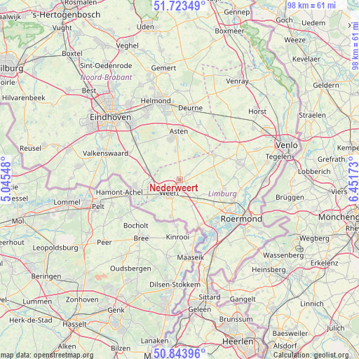
Nederweert GPS coordinates[2]
51° 17' 8.988" North, 5° 44' 54.996" East
| Map corner | latitude | longitude |
|---|---|---|
| Upper-left | 51.72349°, | 5.04548° |
| Center: | 51.28583°, | 5.74861° |
| Lower-right: | 50.84396°, | 6.45173° |
| Map W x H: | 97.8×97.8 km | = 60.8×60.8mi |
| max Lat: | 53.48025° ⇑89.6% North |
| Nederweert: | 51.28583° |
| min Lat: | ⇓10.4% South 50.76917° |
| min Long | Nederweert | max Long |
| 3.38611° | 5.74861° | 7.16528° |
| W 54.5%⇐ | ⇒45.5% E |
Elevation
Elevation of Nederweert is 36 m = 118 ft, and this is 21 m = 69 ft above average elevation for this country.
| Max E: |
203 m = 666 ft | 8.8% |
| Nederweert | 36 m 118 ft | |
| Avg. | 15 m = 49 ft | |
Min E: |
-6 m = -20 ft | 91.2% |
See also: Netherlands elevation on elevation.city.
Geographical zone
Nederweert is located in North temperate zone (between Tropic of Cancer and the Arctic Circle). Distance of this North polar circle is 1698.7 km =1055.5 mi to North.| Distance of | km | miles | from Nederweert |
|---|---|---|---|
| North Pole | 4304.6 | 2674.8 | to North |
| Arctic Circle | 1698.7 | 1055.5 | to North |
| Tropic Cancer | 3096.5 | 1924.1 | to South |
| Equator | 5702.4 | 3543.3 | to South |


Nearby cities:
15 places around Nederweert: (largest is in red/bold)
• Altweerterheide
8.7 km =5.4 mi,  213°
213°
• Budschop
0.7 km =0.4 mi,  96°
96°
• Keent
5.9 km =3.7 mi, 214°
• Kelpen-Oler
9.3 km =5.8 mi,  144°
144°
• Laar
3.2 km =2 mi,  249°
249°
• Leuken
3.8 km =2.4 mi,  194°
194°
• Leveroy
8 km =5 mi,  120°
120°
• Maarheeze
9.6 km =6 mi,  287°
287°
• Moesel
5.7 km =3.5 mi,  202°
202°
• Ospel
2.8 km =1.7 mi,  62°
62°
• Someren-Eind
8 km =5 mi,  352°
352°
• Stramproy
10.4 km =6.5 mi, 191°
• Swartbroek
6.4 km =4 mi,  164°
164°
• Tungelroy
8.3 km =5.2 mi, 188°
• Weert
4.8 km =3 mi,  217°
217°
Sources, notices
• [Note1] Compared only with cities in Netherlands existing in our database
• [Src1] Map data: © OpenStreetMap contributors (CC-BY-SA)
• [Src2] Other city data from geonames.org with taken over terms of usage.
• [Src3] Geographical zone / Annual Mean Temperature by Robert A. Rohde @ Wikipedia
