Keent geodata
Keent (Limburg) is a populated place; located in Netherlands in Europe/Amsterdam (GMT+2) time zone. With population of 4,465 people, there are 539 cities with bigger population in this country. Compared to other cities in Netherlands, 90.6% of cities are located further ↑North; 51.8% of cities are located further ←West and 91.2% of cities have lower elevation than Keent. Note1


Keent GPS coordinates[2]
51° 14' 31.848" North, 5° 42' 2.844" East
| Map corner | latitude | longitude |
|---|---|---|
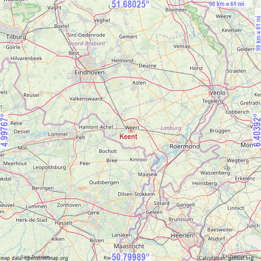
| Upper-left | 51.68025°, | 4.99767° |
| Center: | 51.24218°, | 5.70079° |
| Lower-right: | 50.79989°, | 6.40392° |
| Map W x H: | 97.9×97.9 km | = 60.8×60.8mi |
| max Lat: | 53.48025° ⇑90.6% North |
| Keent: | 51.24218° |
| min Lat: | ⇓9.4% South 50.76917° |
| min Long | Keent | max Long |
| 3.38611° | 5.70079° | 7.16528° |
| W 51.8%⇐ | ⇒48.2% E |
Elevation
Elevation of Keent is 36 m = 118 ft, and this is 21 m = 69 ft above average elevation for this country.
| Max E: |
203 m = 666 ft | 8.8% |
| Keent | 36 m 118 ft | |
| Avg. | 15 m = 49 ft | |
Min E: |
-6 m = -20 ft | 91.2% |
See also: Netherlands elevation on elevation.city.
Geographical zone
Keent is located in North temperate zone (between Tropic of Cancer and the Arctic Circle). Distance of this North polar circle is 1703.6 km =1058.6 mi to North.| Distance of | km | miles | from Keent |
|---|---|---|---|
| North Pole | 4309.5 | 2677.8 | to North |
| Arctic Circle | 1703.6 | 1058.6 | to North |
| Tropic Cancer | 3091.7 | 1921.1 | to South |
| Equator | 5697.6 | 3540.3 | to South |


Nearby cities:
15 places around Keent: (largest is in red/bold)
• Altweerterheide
2.8 km =1.7 mi,  212°
212°
• Budel
9.3 km =5.8 mi,  290°
290°
• Budel-Dorplein
7.9 km =4.9 mi,  265°
265°
• Budel-Schoot
9.5 km =5.9 mi, 273°
• Budschop
6.3 km =3.9 mi,  40°
40°
• Kelpen-Oler
9.1 km =5.7 mi,  107°
107°
• Laar
3.8 km =2.4 mi,  5°
5°
• Leuken
2.6 km =1.6 mi,  63°
63°
• Moesel
1.3 km =0.8 mi, 110°
• Nederweert
5.9 km =3.7 mi,  34°
34°
• Ospel
8.5 km =5.3 mi, 43°
• Stramproy
5.5 km =3.4 mi,  166°
166°
• Swartbroek
5.2 km =3.2 mi,  104°
104°
• Tungelroy
4 km =2.5 mi,  148°
148°
• Weert
1.1 km =0.7 mi,  22°
22°
Sources, notices
• [Note1] Compared only with cities in Netherlands existing in our database
• [Src1] Map data: © OpenStreetMap contributors (CC-BY-SA)
• [Src2] Other city data from geonames.org with taken over terms of usage.
• [Src3] Geographical zone / Annual Mean Temperature by Robert A. Rohde @ Wikipedia
