Leuken geodata
Leuken (Limburg) is a populated place; located in Netherlands in Europe/Amsterdam (GMT+2) time zone. With population of 3,805 people, there are 620 cities with bigger population in this country. Compared to other cities in Netherlands, 90.3% of cities are located further ↑North; 54% of cities are located further ←West and 89.2% of cities have lower elevation than Leuken. Note1


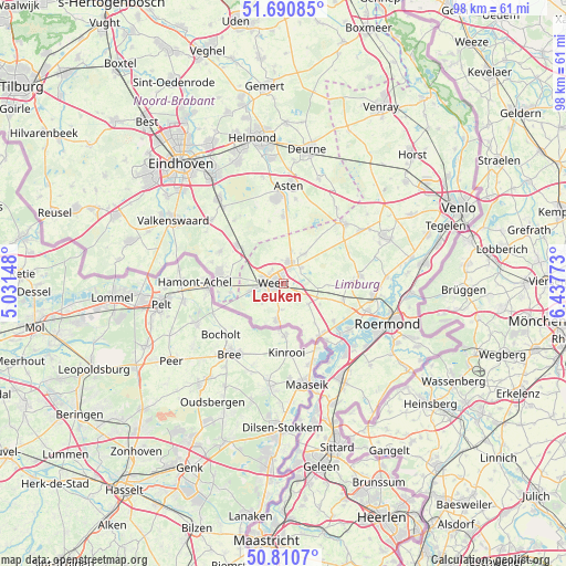
Leuken GPS coordinates[2]
51° 15' 10.368" North, 5° 44' 4.56" East
| Map corner | latitude | longitude |
|---|---|---|
| Upper-left | 51.69085°, | 5.03148° |
| Center: | 51.25288°, | 5.7346° |
| Lower-right: | 50.8107°, | 6.43773° |
| Map W x H: | 97.9×97.9 km | = 60.8×60.8mi |
| max Lat: | 53.48025° ⇑90.3% North |
| Leuken: | 51.25288° |
| min Lat: | ⇓9.7% South 50.76917° |
| min Long | Leuken | max Long |
| 3.38611° | 5.7346° | 7.16528° |
| W 54%⇐ | ⇒46% E |
Elevation
Elevation of Leuken is 32 m = 105 ft, and this is 17 m = 56 ft above average elevation for this country.
| Max E: |
203 m = 666 ft | 10.8% |
| Leuken | 32 m 105 ft | |
| Avg. | 15 m = 49 ft | |
Min E: |
-6 m = -20 ft | 89.2% |
See also: Netherlands elevation on elevation.city.
Geographical zone
Leuken is located in North temperate zone (between Tropic of Cancer and the Arctic Circle). Distance of this North polar circle is 1702.4 km =1057.8 mi to North.| Distance of | km | miles | from Leuken |
|---|---|---|---|
| North Pole | 4308.3 | 2677.1 | to North |
| Arctic Circle | 1702.4 | 1057.8 | to North |
| Tropic Cancer | 3092.9 | 1921.8 | to South |
| Equator | 5698.8 | 3541.1 | to South |


Nearby cities:
15 places around Leuken: (largest is in red/bold)
• Altweerterheide
5.3 km =3.3 mi,  227°
227°
• Budel-Dorplein
10.4 km =6.5 mi,  260°
260°
• Budschop
4 km =2.5 mi,  25°
25°
• Keent
2.6 km =1.6 mi,  243°
243°
• Kelpen-Oler
7.4 km =4.6 mi,  121°
121°
• Laar
3.3 km =2.1 mi,  321°
321°
• Leveroy
7.8 km =4.8 mi,  93°
93°
• Maarheeze
10.5 km =6.5 mi,  308°
308°
• Moesel
2 km =1.2 mi,  215°
215°
• Nederweert
3.8 km =2.4 mi,  14°
14°
• Ospel
6.1 km =3.8 mi,  35°
35°
• Stramproy
6.6 km =4.1 mi,  189°
189°
• Swartbroek
3.7 km =2.3 mi,  133°
133°
• Tungelroy
4.6 km =2.9 mi,  183°
183°
• Weert
1.9 km =1.2 mi,  266°
266°
Sources, notices
• [Note1] Compared only with cities in Netherlands existing in our database
• [Src1] Map data: © OpenStreetMap contributors (CC-BY-SA)
• [Src2] Other city data from geonames.org with taken over terms of usage.
• [Src3] Geographical zone / Annual Mean Temperature by Robert A. Rohde @ Wikipedia
