Swartbroek geodata
Swartbroek (Limburg) is a populated place; located in Netherlands in Europe/Amsterdam (GMT+2) time zone. With population of 555 people, there are 1772 cities with bigger population in this country. Compared to other cities in Netherlands, 91% of cities are located further ↑North; 56% of cities are located further ←West and 88.5% of cities have lower elevation than Swartbroek. Note1


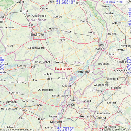
Swartbroek GPS coordinates[2]
51° 13' 48" North, 5° 46' 24.996" East
| Map corner | latitude | longitude |
|---|---|---|
| Upper-left | 51.66819°, | 5.07048° |
| Center: | 51.23°, | 5.77361° |
| Lower-right: | 50.7876°, | 6.47673° |
| Map W x H: | 97.9×97.9 km | = 60.8×60.8mi |
| max Lat: | 53.48025° ⇑91% North |
| Swartbroek: | 51.23° |
| min Lat: | ⇓9% South 50.76917° |
| min Long | Swartbroek | max Long |
| 3.38611° | 5.77361° | 7.16528° |
| W 56%⇐ | ⇒44% E |
Elevation
Elevation of Swartbroek is 31 m = 102 ft, and this is 16 m = 52 ft above average elevation for this country.
| Max E: |
203 m = 666 ft | 11.5% |
| Swartbroek | 31 m 102 ft | |
| Avg. | 15 m = 49 ft | |
Min E: |
-6 m = -20 ft | 88.5% |
See also: Netherlands elevation on elevation.city.
Geographical zone
Swartbroek is located in North temperate zone (between Tropic of Cancer and the Arctic Circle). Distance of this North polar circle is 1704.9 km =1059.4 mi to North.| Distance of | km | miles | from Swartbroek |
|---|---|---|---|
| North Pole | 4310.8 | 2678.6 | to North |
| Arctic Circle | 1704.9 | 1059.4 | to North |
| Tropic Cancer | 3090.3 | 1920.2 | to South |
| Equator | 5696.2 | 3539.5 | to South |


Nearby cities:
15 places around Swartbroek: (largest is in red/bold)
• Altweerterheide
6.7 km =4.2 mi,  261°
261°
• Budschop
6.2 km =3.9 mi,  350°
350°
• Heythuysen
9 km =5.6 mi,  75°
75°
• Keent
5.2 km =3.2 mi,  284°
284°
• Kelpen-Oler
3.9 km =2.4 mi,  109°
109°
• Laar
7 km =4.3 mi,  317°
317°
• Leuken
3.7 km =2.3 mi,  313°
313°
• Leveroy
5.5 km =3.4 mi,  67°
67°
• Moesel
4 km =2.5 mi, 283°
• Nederweert
6.4 km =4 mi,  344°
344°
• Ospel
7.5 km =4.7 mi,  5°
5°
• Stramproy
5.5 km =3.4 mi,  223°
223°
• Thorn
9 km =5.6 mi,  148°
148°
• Tungelroy
3.6 km =2.2 mi,  235°
235°
• Weert
5.2 km =3.2 mi,  297°
297°
Sources, notices
• [Note1] Compared only with cities in Netherlands existing in our database
• [Src1] Map data: © OpenStreetMap contributors (CC-BY-SA)
• [Src2] Other city data from geonames.org with taken over terms of usage.
• [Src3] Geographical zone / Annual Mean Temperature by Robert A. Rohde @ Wikipedia
