Almere Stad geodata
Almere Stad (Flevoland) is a populated place; located in Netherlands in Europe/Amsterdam (GMT+2) time zone. With population of 176,432 people, there are 7 cities with bigger population in this country. Compared to other cities in Netherlands, 68.4% of cities are located further ↓South; 66.1% of cities are located further →East and 99.2% of cities have higher elevation than Almere Stad. Note1


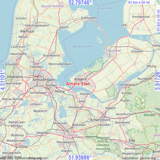
Almere Stad GPS coordinates[2]
52° 22' 12.9" North, 5° 12' 50.868" East
| Map corner | latitude | longitude |
|---|---|---|
| Upper-left | 52.79746°, | 4.51101° |
| Center: | 52.37025°, | 5.21413° |
| Lower-right: | 51.93886°, | 5.91726° |
| Map W x H: | 95.5×95.5 km | = 59.3×59.3mi |
| max Lat: | 53.48025° ⇑31.6% North |
| Almere Stad: | 52.37025° |
| min Lat: | ⇓68.4% South 50.76917° |
| min Long | Almere Stad | max Long |
| 3.38611° | 5.21413° | 7.16528° |
| W 33.9%⇐ | ⇒66.1% E |
Elevation
Elevation of Almere Stad is -3 m = -10 ft, and this is 18 m = 59 ft below average elevation for this country.
| Max E: |
203 m = 666 ft | 99.2% |
| Avg. | 15 m = 49 ft | |
| Almere Stad | -3 m = -10 ft | |
Min E: |
-6 m = -20 ft | 0.8% |
See also: Almere Stad elevation on elevation.city.
Geographical zone
Almere Stad is located in North temperate zone (between Tropic of Cancer and the Arctic Circle). Distance of this North polar circle is 1578.1 km =980.6 mi to North.| Distance of | km | miles | from Almere Stad |
|---|---|---|---|
| North Pole | 4184 | 2599.8 | to North |
| Arctic Circle | 1578.1 | 980.6 | to North |
| Tropic Cancer | 3217.1 | 1999 | to South |
| Equator | 5823 | 3618.2 | to South |


Nearby cities:
15 places around Almere Stad: (largest is in red/bold)
• Ankeveense Rade
14.6 km =9.1 mi,  211°
211°
• Bijvanck
10 km =6.2 mi,  159°
159°
• Blaricum
11 km =6.8 mi,  170°
170°
• Bussum
11.4 km =7.1 mi,  198°
198°
• Driemond
15.2 km =9.4 mi,  241°
241°
• Eemdijk
15.1 km =9.4 mi,  148°
148°
• Eemnes
13.3 km =8.3 mi, 166°
• Hilversumse Meent
12.2 km =7.6 mi, 205°
• Huizen
8.1 km =5 mi, 166°
• Laren
12.7 km =7.9 mi,  175°
175°
• Marken
12.4 km =7.7 mi,  322°
322°
• Muiden
10.8 km =6.7 mi,  245°
245°
• Muiderberg
8 km =5 mi,  232°
232°
• Naarden
9 km =5.6 mi, 202°
• Weesp
13.6 km =8.5 mi, 239°
Sources, notices
• [Note1] Compared only with cities in Netherlands existing in our database
• [Src1] Map data: © OpenStreetMap contributors (CC-BY-SA)
• [Src2] Other city data from geonames.org with taken over terms of usage.
• [Src3] Geographical zone / Annual Mean Temperature by Robert A. Rohde @ Wikipedia
