Zuidlaren geodata
Zuidlaren (Drenthe) is a populated place; located in Netherlands in Europe/Amsterdam (GMT+2) time zone. With population of 3,905 people, there are 601 cities with bigger population in this country. Compared to other cities in Netherlands, 88.6% of cities are located further ↓South; 93% of cities are located further ←West and 64.6% of cities have lower elevation than Zuidlaren. Note1


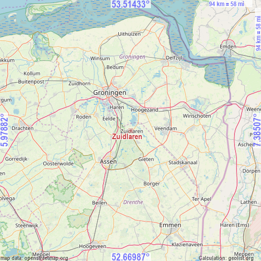
Zuidlaren GPS coordinates[2]
53° 5' 39.012" North, 6° 40' 54.984" East
| Map corner | latitude | longitude |
|---|---|---|
| Upper-left | 53.51433°, | 5.97882° |
| Center: | 53.09417°, | 6.68194° |
| Lower-right: | 52.66987°, | 7.38507° |
| Map W x H: | 93.9×93.9 km | = 58.3×58.3mi |
| max Lat: | 53.48025° ⇑11.4% North |
| Zuidlaren: | 53.09417° |
| min Lat: | ⇓88.6% South 50.76917° |
| min Long | Zuidlaren | max Long |
| 3.38611° | 6.68194° | 7.16528° |
| W 93%⇐ | ⇒7% E |
Elevation
Elevation of Zuidlaren is 12 m = 39 ft, and this is 3 m = 10 ft below average elevation for this country.
| Max E: |
203 m = 666 ft | 35.4% |
| Avg. | 15 m = 49 ft | |
| Zuidlaren | 12 m = 39 ft | |
Min E: |
-6 m = -20 ft | 64.6% |
See also: Netherlands elevation on elevation.city.
Geographical zone
Zuidlaren is located in North temperate zone (between Tropic of Cancer and the Arctic Circle). Distance of this North polar circle is 1497.7 km =930.6 mi to North.| Distance of | km | miles | from Zuidlaren |
|---|---|---|---|
| North Pole | 4103.5 | 2549.8 | to North |
| Arctic Circle | 1497.7 | 930.6 | to North |
| Tropic Cancer | 3297.6 | 2049 | to South |
| Equator | 5903.5 | 3668.3 | to South |


Nearby cities:
15 places around Zuidlaren: (largest is in red/bold)
• Annen
4.8 km =3 mi,  148°
148°
• Eelde
9.2 km =5.7 mi,  300°
300°
• Eext
9.2 km =5.7 mi,  157°
157°
• Foxhol
8.6 km =5.3 mi,  18°
18°
• Glimmen
6.1 km =3.8 mi,  324°
324°
• Hoogezand
9.2 km =5.7 mi,  35°
35°
• Kiel-Windeweer
6.8 km =4.2 mi,  72°
72°
• Martenshoek
8.3 km =5.2 mi, 22°
• Meerwijck
6.2 km =3.9 mi, 19°
• Paterswolde
9.6 km =6 mi,  305°
305°
• Schipborg
2.3 km =1.4 mi,  199°
199°
• Tynaarlo
4.7 km =2.9 mi,  246°
246°
• Vries
7.3 km =4.5 mi, 252°
• Westlaren
1.6 km =1 mi,  227°
227°
• Yde
6.4 km =4 mi,  292°
292°
Sources, notices
• [Note1] Compared only with cities in Netherlands existing in our database
• [Src1] Map data: © OpenStreetMap contributors (CC-BY-SA)
• [Src2] Other city data from geonames.org with taken over terms of usage.
• [Src3] Geographical zone / Annual Mean Temperature by Robert A. Rohde @ Wikipedia
