Lent geodata
Lent (Gelderland) is a populated place; located in Netherlands in Europe/Amsterdam (GMT+2) time zone. With population of 9,160 people, there are 311 cities with bigger population in this country. Compared to other cities in Netherlands, 60.6% of cities are located further ↑North; 61.8% of cities are located further ←West and 62% of cities have lower elevation than Lent. Note1


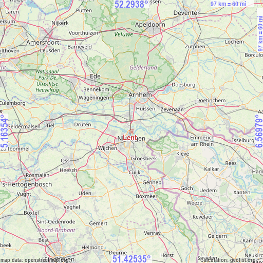
Lent GPS coordinates[2]
51° 51' 42.012" North, 5° 52' 0.012" East
| Map corner | latitude | longitude |
|---|---|---|
| Upper-left | 52.2938°, | 5.16354° |
| Center: | 51.86167°, | 5.86667° |
| Lower-right: | 51.42535°, | 6.56979° |
| Map W x H: | 96.6×96.6 km | = 60×60mi |
| max Lat: | 53.48025° ⇑60.6% North |
| Lent: | 51.86167° |
| min Lat: | ⇓39.4% South 50.76917° |
| min Long | Lent | max Long |
| 3.38611° | 5.86667° | 7.16528° |
| W 61.8%⇐ | ⇒38.2% E |
Elevation
Elevation of Lent is 11 m = 36 ft, and this is 4 m = 13 ft below average elevation for this country.
| Max E: |
203 m = 666 ft | 38% |
| Avg. | 15 m = 49 ft | |
| Lent | 11 m = 36 ft | |
Min E: |
-6 m = -20 ft | 62% |
See also: Netherlands elevation on elevation.city.
Geographical zone
Lent is located in North temperate zone (between Tropic of Cancer and the Arctic Circle). Distance of this North polar circle is 1634.7 km =1015.8 mi to North.| Distance of | km | miles | from Lent |
|---|---|---|---|
| North Pole | 4240.6 | 2635 | to North |
| Arctic Circle | 1634.7 | 1015.8 | to North |
| Tropic Cancer | 3160.6 | 1963.9 | to South |
| Equator | 5766.5 | 3583.1 | to South |


Nearby cities:
15 places around Lent: (largest is in red/bold)
• Bemmel
4 km =2.5 mi,  33°
33°
• Berg en Dal
5.6 km =3.5 mi,  142°
142°
• Beuningen
6.9 km =4.3 mi,  269°
269°
• Brakkenstein
5.4 km =3.4 mi,  180°
180°
• Elst
6.6 km =4.1 mi,  344°
344°
• Haalderen
5.2 km =3.2 mi,  56°
56°
• Hatert
6.6 km =4.1 mi,  201°
201°
• Hees
3.5 km =2.2 mi,  229°
229°
• Heilig Landstichting
4.9 km =3 mi,  166°
166°
• Hengstdal
3.4 km =2.1 mi,  160°
160°
• Hunnerberg
2.3 km =1.4 mi, 159°
• Lindenholt
6 km =3.7 mi,  237°
237°
• Nijmegen
2.3 km =1.4 mi, 204°
• Ooij
5 km =3.1 mi,  98°
98°
• Oosterhout
3.4 km =2.1 mi,  306°
306°
Sources, notices
• [Note1] Compared only with cities in Netherlands existing in our database
• [Src1] Map data: © OpenStreetMap contributors (CC-BY-SA)
• [Src2] Other city data from geonames.org with taken over terms of usage.
• [Src3] Geographical zone / Annual Mean Temperature by Robert A. Rohde @ Wikipedia
