Lindenholt geodata
Lindenholt (Gelderland) is a section of populated place; located in Netherlands in Europe/Amsterdam (GMT+2) time zone. With population of 16,121 people, there are 215 cities with bigger population in this country. Compared to other cities in Netherlands, 62.2% of cities are located further ↑North; 57.4% of cities are located further ←West and 55.1% of cities have lower elevation than Lindenholt. Note1


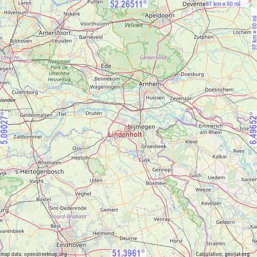
Lindenholt GPS coordinates[2]
51° 49' 57.72" North, 5° 47' 36.24" East
| Map corner | latitude | longitude |
|---|---|---|
| Upper-left | 52.26511°, | 5.09027° |
| Center: | 51.8327°, | 5.7934° |
| Lower-right: | 51.3961°, | 6.49652° |
| Map W x H: | 96.6×96.6 km | = 60×60mi |
| max Lat: | 53.48025° ⇑62.2% North |
| Lindenholt: | 51.8327° |
| min Lat: | ⇓37.8% South 50.76917° |
| min Long | Lindenholt | max Long |
| 3.38611° | 5.7934° | 7.16528° |
| W 57.4%⇐ | ⇒42.6% E |
Elevation
Elevation of Lindenholt is 8 m = 26 ft, and this is 7 m = 23 ft below average elevation for this country.
| Max E: |
203 m = 666 ft | 44.9% |
| Avg. | 15 m = 49 ft | |
| Lindenholt | 8 m = 26 ft | |
Min E: |
-6 m = -20 ft | 55.1% |
See also: Netherlands elevation on elevation.city.
Geographical zone
Lindenholt is located in North temperate zone (between Tropic of Cancer and the Arctic Circle). Distance of this North polar circle is 1637.9 km =1017.7 mi to North.| Distance of | km | miles | from Lindenholt |
|---|---|---|---|
| North Pole | 4243.8 | 2637 | to North |
| Arctic Circle | 1637.9 | 1017.7 | to North |
| Tropic Cancer | 3157.3 | 1961.9 | to South |
| Equator | 5763.3 | 3581.1 | to South |


Nearby cities:
15 places around Lindenholt: (largest is in red/bold)
• Alverna
3.9 km =2.4 mi,  216°
216°
• Beuningen
3.6 km =2.2 mi,  329°
329°
• Brakkenstein
5.4 km =3.4 mi,  113°
113°
• Hatert
3.9 km =2.4 mi,  138°
138°
• Hees
2.6 km =1.6 mi,  68°
68°
• Heilig Landstichting
6.4 km =4 mi,  103°
103°
• Hengstdal
6.2 km =3.9 mi,  89°
89°
• Hernen
7.8 km =4.8 mi,  271°
271°
• Hunnerberg
6 km =3.7 mi,  79°
79°
• Lent
6 km =3.7 mi,  57°
57°
• Nederasselt
7.6 km =4.7 mi,  206°
206°
• Nijmegen
4.2 km =2.6 mi, 75°
• Oosterhout
5.7 km =3.5 mi,  23°
23°
• Valendries
5 km =3.1 mi,  234°
234°
• Wijchen
5.4 km =3.4 mi,  240°
240°
Sources, notices
• [Note1] Compared only with cities in Netherlands existing in our database
• [Src1] Map data: © OpenStreetMap contributors (CC-BY-SA)
• [Src2] Other city data from geonames.org with taken over terms of usage.
• [Src3] Geographical zone / Annual Mean Temperature by Robert A. Rohde @ Wikipedia
