Nijmegen geodata
Nijmegen (Gelderland) is a populated place; located in Netherlands in Europe/Amsterdam (GMT+2) time zone. With population of 158,732 people, there are 9 cities with bigger population in this country. Compared to other cities in Netherlands, 61.7% of cities are located further ↑North; 61.2% of cities are located further ←West and 83.5% of cities have lower elevation than Nijmegen. Note1


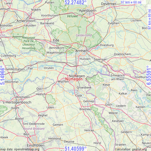
Nijmegen GPS coordinates[2]
51° 50' 33" North, 5° 51' 10.008" East
| Map corner | latitude | longitude |
|---|---|---|
| Upper-left | 52.27482°, | 5.14966° |
| Center: | 51.8425°, | 5.85278° |
| Lower-right: | 51.40599°, | 6.55591° |
| Map W x H: | 96.6×96.6 km | = 60×60mi |
| max Lat: | 53.48025° ⇑61.7% North |
| Nijmegen: | 51.8425° |
| min Lat: | ⇓38.3% South 50.76917° |
| min Long | Nijmegen | max Long |
| 3.38611° | 5.85278° | 7.16528° |
| W 61.2%⇐ | ⇒38.8% E |
Elevation
Elevation of Nijmegen is 25 m = 82 ft, and this is 10 m = 33 ft above average elevation for this country.
| Max E: |
203 m = 666 ft | 16.5% |
| Nijmegen | 25 m 82 ft | |
| Avg. | 15 m = 49 ft | |
Min E: |
-6 m = -20 ft | 83.5% |
See also: Nijmegen elevation on elevation.city.
Geographical zone
Nijmegen is located in North temperate zone (between Tropic of Cancer and the Arctic Circle). Distance of this North polar circle is 1636.8 km =1017.1 mi to North.| Distance of | km | miles | from Nijmegen |
|---|---|---|---|
| North Pole | 4242.7 | 2636.3 | to North |
| Arctic Circle | 1636.8 | 1017.1 | to North |
| Tropic Cancer | 3158.4 | 1962.5 | to South |
| Equator | 5764.3 | 3581.8 | to South |


Nearby cities:
15 places around Nijmegen: (largest is in red/bold)
• Alverna
7.7 km =4.8 mi,  236°
236°
• Bemmel
6.3 km =3.9 mi,  29°
29°
• Berg en Dal
5 km =3.1 mi,  117°
117°
• Beuningen
6.3 km =3.9 mi,  289°
289°
• Brakkenstein
3.4 km =2.1 mi,  165°
165°
• Haalderen
7.2 km =4.5 mi,  46°
46°
• Hatert
4.3 km =2.7 mi,  200°
200°
• Hees
1.7 km =1.1 mi,  265°
265°
• Heilig Landstichting
3.3 km =2.1 mi,  141°
141°
• Hengstdal
2.3 km =1.4 mi, 115°
• Hunnerberg
1.8 km =1.1 mi,  91°
91°
• Lent
2.3 km =1.4 mi,  24°
24°
• Lindenholt
4.2 km =2.6 mi,  255°
255°
• Ooij
6.1 km =3.8 mi,  77°
77°
• Oosterhout
4.5 km =2.8 mi,  336°
336°
In other languages:
- In Spanish: Nimega
- In France: Nimègue
- In German: Nimwegen
- In Italian: Nimega
- In Russian: Неймеген
- In Chinese: 奈梅亨
Sources, notices
• [Note1] Compared only with cities in Netherlands existing in our database
• [Src1] Map data: © OpenStreetMap contributors (CC-BY-SA)
• [Src2] Other city data from geonames.org with taken over terms of usage.
• [Src3] Geographical zone / Annual Mean Temperature by Robert A. Rohde @ Wikipedia
