Koekange geodata
Koekange (Drenthe) is a populated place; located in Netherlands in Europe/Amsterdam (GMT+2) time zone. With population of 1,085 people, there are 1344 cities with bigger population in this country. Compared to other cities in Netherlands, 76.5% of cities are located further ↓South; 85.9% of cities are located further ←West and 74.9% of cities have higher elevation than Koekange. Note1


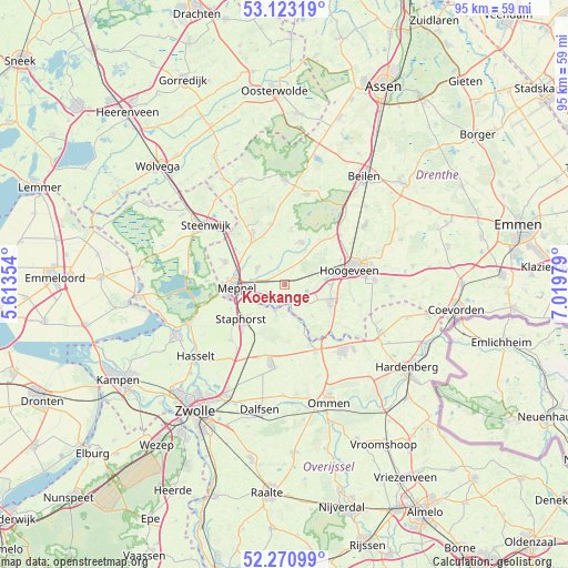
Koekange GPS coordinates[2]
52° 41' 57.012" North, 6° 19' 0.012" East
| Map corner | latitude | longitude |
|---|---|---|
| Upper-left | 53.12319°, | 5.61354° |
| Center: | 52.69917°, | 6.31667° |
| Lower-right: | 52.27099°, | 7.01979° |
| Map W x H: | 94.8×94.8 km | = 58.9×58.9mi |
| max Lat: | 53.48025° ⇑23.5% North |
| Koekange: | 52.69917° |
| min Lat: | ⇓76.5% South 50.76917° |
| min Long | Koekange | max Long |
| 3.38611° | 6.31667° | 7.16528° |
| W 85.9%⇐ | ⇒14.1% E |
Elevation
Elevation of Koekange is 2 m = 7 ft, and this is 13 m = 43 ft below average elevation for this country.
| Max E: |
203 m = 666 ft | 74.9% |
| Avg. | 15 m = 49 ft | |
| Koekange | 2 m = 7 ft | |
Min E: |
-6 m = -20 ft | 25.1% |
See also: Netherlands elevation on elevation.city.
Geographical zone
Koekange is located in North temperate zone (between Tropic of Cancer and the Arctic Circle). Distance of this North polar circle is 1541.6 km =957.9 mi to North.| Distance of | km | miles | from Koekange |
|---|---|---|---|
| North Pole | 4147.5 | 2577.1 | to North |
| Arctic Circle | 1541.6 | 957.9 | to North |
| Tropic Cancer | 3253.7 | 2021.8 | to South |
| Equator | 5859.6 | 3641 | to South |


Nearby cities:
15 places around Koekange: (largest is in red/bold)
• Alteveer
11.7 km =7.3 mi,  103°
103°
• Darp
11.3 km =7 mi,  318°
318°
• De Wijk
3.4 km =2.1 mi,  211°
211°
• Havelte
9.4 km =5.8 mi,  326°
326°
• Hoogeveen
11.1 km =6.9 mi,  76°
76°
• IJhorst
4.8 km =3 mi,  200°
200°
• Kerkenveld
12.8 km =8 mi,  105°
105°
• Krakeel
13.4 km =8.3 mi, 78°
• Meppel
8.2 km =5.1 mi,  267°
267°
• Nieuw Moscou
15.2 km =9.4 mi, 101°
• Ruinen
7.5 km =4.7 mi,  19°
19°
• Ruinerwold
5.3 km =3.3 mi,  300°
300°
• Staphorst
9.3 km =5.8 mi,  229°
229°
• Uffelte
10.4 km =6.5 mi,  346°
346°
• Wolfsbos
12.4 km =7.7 mi, 80°
Sources, notices
• [Note1] Compared only with cities in Netherlands existing in our database
• [Src1] Map data: © OpenStreetMap contributors (CC-BY-SA)
• [Src2] Other city data from geonames.org with taken over terms of usage.
• [Src3] Geographical zone / Annual Mean Temperature by Robert A. Rohde @ Wikipedia
